You are here: Home > Network List > TA - USArray Transportable Network (new EarthScope stations) Stations List
> Station C37A Embarrass, MN, USA > Earthquake Result Viewer
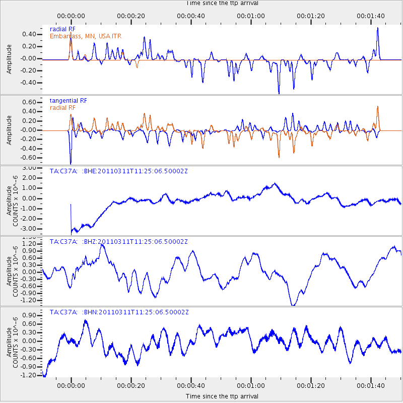
C37A Embarrass, MN, USA - Earthquake Result Viewer
*The percent match for this event was below the threshold and hence no stack was calculated.
| Earthquake location: |
Near East Coast Of Honshu, Japan |
| Earthquake latitude/longitude: |
36.4/141.8 |
| Earthquake time(UTC): |
2011/03/11 (070) 11:13:12 GMT |
| Earthquake Depth: |
26 km |
| Earthquake Magnitude: |
5.5 MB |
| Earthquake Catalog/Contributor: |
WHDF/NEIC |
|
| Network: |
TA USArray Transportable Network (new EarthScope stations) |
| Station: |
C37A Embarrass, MN, USA |
| Lat/Lon: |
47.73 N/92.19 W |
| Elevation: |
447 m |
|
| Distance: |
83.4 deg |
| Az: |
33.338 deg |
| Baz: |
318.933 deg |
| Ray Param: |
$rayparam |
*The percent match for this event was below the threshold and hence was not used in the summary stack. |
|
| Radial Match: |
45.91306 % |
| Radial Bump: |
283 |
| Transverse Match: |
48.942528 % |
| Transverse Bump: |
359 |
| SOD ConfigId: |
356183 |
| Insert Time: |
2011-08-14 21:55:12.006 +0000 |
| GWidth: |
2.5 |
| Max Bumps: |
400 |
| Tol: |
0.001 |
|
Signal To Noise
| Channel | StoN | STA | LTA |
| TA:C37A: :BHZ:20110311T11:25:06.50002Z | 1.2101625 | 4.7223247E-7 | 3.9022237E-7 |
| TA:C37A: :BHN:20110311T11:25:06.50002Z | 0.31338325 | 2.520691E-7 | 8.043477E-7 |
| TA:C37A: :BHE:20110311T11:25:06.50002Z | 1.1374257 | 1.329701E-6 | 1.1690444E-6 |
| Arrivals |
| Ps | |
| PpPs | |
| PsPs/PpSs | |


