You are here: Home > Network List > TA - USArray Transportable Network (new EarthScope stations) Stations List
> Station O37A Wolven Farm, McFall, MO, USA > Earthquake Result Viewer
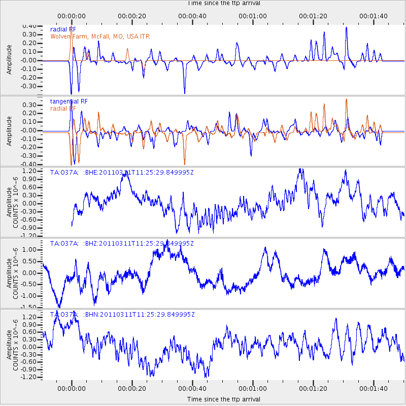
O37A Wolven Farm, McFall, MO, USA - Earthquake Result Viewer
*The percent match for this event was below the threshold and hence no stack was calculated.
| Earthquake location: |
Near East Coast Of Honshu, Japan |
| Earthquake latitude/longitude: |
36.4/141.8 |
| Earthquake time(UTC): |
2011/03/11 (070) 11:13:12 GMT |
| Earthquake Depth: |
26 km |
| Earthquake Magnitude: |
5.5 MB |
| Earthquake Catalog/Contributor: |
WHDF/NEIC |
|
| Network: |
TA USArray Transportable Network (new EarthScope stations) |
| Station: |
O37A Wolven Farm, McFall, MO, USA |
| Lat/Lon: |
40.17 N/94.15 W |
| Elevation: |
284 m |
|
| Distance: |
88.1 deg |
| Az: |
39.425 deg |
| Baz: |
318.026 deg |
| Ray Param: |
$rayparam |
*The percent match for this event was below the threshold and hence was not used in the summary stack. |
|
| Radial Match: |
62.190018 % |
| Radial Bump: |
318 |
| Transverse Match: |
53.308445 % |
| Transverse Bump: |
400 |
| SOD ConfigId: |
356183 |
| Insert Time: |
2011-08-14 22:03:13.668 +0000 |
| GWidth: |
2.5 |
| Max Bumps: |
400 |
| Tol: |
0.001 |
|
Signal To Noise
| Channel | StoN | STA | LTA |
| TA:O37A: :BHZ:20110311T11:25:29.849995Z | 1.6223533 | 7.698724E-7 | 4.7454049E-7 |
| TA:O37A: :BHN:20110311T11:25:29.849995Z | 1.6644645 | 1.1329753E-6 | 6.806846E-7 |
| TA:O37A: :BHE:20110311T11:25:29.849995Z | 1.4005307 | 5.59487E-7 | 3.9948213E-7 |
| Arrivals |
| Ps | |
| PpPs | |
| PsPs/PpSs | |


