You are here: Home > Network List > CI - Caltech Regional Seismic Network Stations List
> Station MPM Manuel Prospect Mine, California, USA > Earthquake Result Viewer
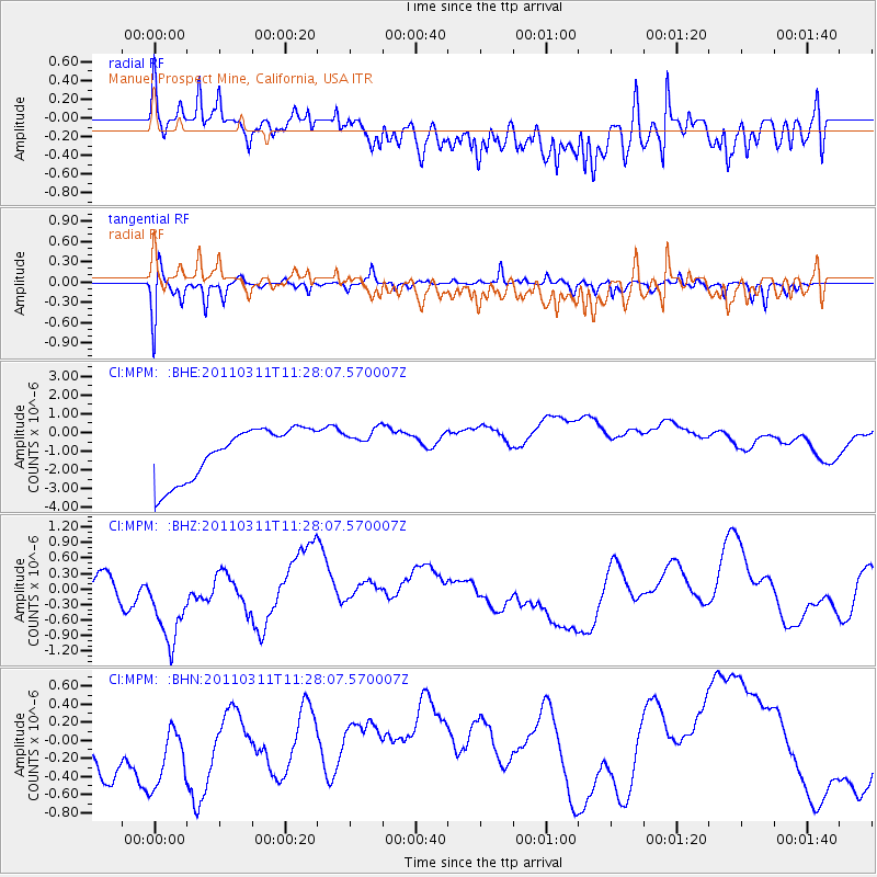
MPM Manuel Prospect Mine, California, USA - Earthquake Result Viewer
*The percent match for this event was below the threshold and hence no stack was calculated.
| Earthquake location: |
Near East Coast Of Honshu, Japan |
| Earthquake latitude/longitude: |
36.6/141.8 |
| Earthquake time(UTC): |
2011/03/11 (070) 11:16:50 GMT |
| Earthquake Depth: |
37 km |
| Earthquake Magnitude: |
5.5 MB |
| Earthquake Catalog/Contributor: |
WHDF/NEIC |
|
| Network: |
CI Caltech Regional Seismic Network |
| Station: |
MPM Manuel Prospect Mine, California, USA |
| Lat/Lon: |
36.06 N/117.49 W |
| Elevation: |
185 m |
|
| Distance: |
76.9 deg |
| Az: |
54.841 deg |
| Baz: |
305.743 deg |
| Ray Param: |
$rayparam |
*The percent match for this event was below the threshold and hence was not used in the summary stack. |
|
| Radial Match: |
57.063244 % |
| Radial Bump: |
400 |
| Transverse Match: |
70.46527 % |
| Transverse Bump: |
400 |
| SOD ConfigId: |
356183 |
| Insert Time: |
2011-08-14 22:54:35.553 +0000 |
| GWidth: |
2.5 |
| Max Bumps: |
400 |
| Tol: |
0.001 |
|
Signal To Noise
| Channel | StoN | STA | LTA |
| CI:MPM: :BHZ:20110311T11:28:07.570007Z | 2.3733191 | 8.2128275E-7 | 3.4604818E-7 |
| CI:MPM: :BHN:20110311T11:28:07.570007Z | 0.7344979 | 9.902581E-7 | 1.3482108E-6 |
| CI:MPM: :BHE:20110311T11:28:07.570007Z | 0.6862115 | 9.380888E-7 | 1.3670549E-6 |
| Arrivals |
| Ps | |
| PpPs | |
| PsPs/PpSs | |


