You are here: Home > Network List > AZ - ANZA Regional Network Stations List
> Station LVA2 AZ.LVA2 > Earthquake Result Viewer
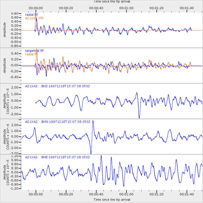
LVA2 AZ.LVA2 - Earthquake Result Viewer
*The percent match for this event was below the threshold and hence no stack was calculated.
| Earthquake location: |
El Salvador |
| Earthquake latitude/longitude: |
13.8/-88.7 |
| Earthquake time(UTC): |
1997/12/18 (352) 15:02:00 GMT |
| Earthquake Depth: |
182 km |
| Earthquake Magnitude: |
5.3 MB, 6.1 UNKNOWN, 6.0 MW |
| Earthquake Catalog/Contributor: |
WHDF/NEIC |
|
| Network: |
AZ ANZA Regional Network |
| Station: |
LVA2 AZ.LVA2 |
| Lat/Lon: |
33.35 N/116.56 W |
| Elevation: |
1435 m |
|
| Distance: |
31.9 deg |
| Az: |
312.307 deg |
| Baz: |
120.88 deg |
| Ray Param: |
$rayparam |
*The percent match for this event was below the threshold and hence was not used in the summary stack. |
|
| Radial Match: |
62.88281 % |
| Radial Bump: |
400 |
| Transverse Match: |
64.427246 % |
| Transverse Bump: |
400 |
| SOD ConfigId: |
4480 |
| Insert Time: |
2010-02-26 19:56:33.954 +0000 |
| GWidth: |
2.5 |
| Max Bumps: |
400 |
| Tol: |
0.001 |
|
Signal To Noise
| Channel | StoN | STA | LTA |
| AZ:LVA2: :BHN:19971218T15:07:38.050Z | 3.652573 | 7.856637E-7 | 2.150987E-7 |
| AZ:LVA2: :BHE:19971218T15:07:38.050Z | 0.83127904 | 2.3141894E-7 | 2.78389E-7 |
| AZ:LVA2: :BHZ:19971218T15:07:38.050Z | 1.8500093 | 7.454738E-7 | 4.0295677E-7 |
| Arrivals |
| Ps | |
| PpPs | |
| PsPs/PpSs | |


