You are here: Home > Network List > AZ - ANZA Regional Network Stations List
> Station LVA2 AZ.LVA2 > Earthquake Result Viewer
LVA2 AZ.LVA2 - Earthquake Result Viewer
*The percent match for this event was below the threshold and hence no stack was calculated.
| Earthquake location: |
South Of Fiji Islands |
| Earthquake latitude/longitude: |
-25.6/-177.5 |
| Earthquake time(UTC): |
1995/10/14 (287) 08:00:41 GMT |
| Earthquake Depth: |
70 km |
| Earthquake Magnitude: |
5.9 MB, 6.2 UNKNOWN, 6.2 MW |
| Earthquake Catalog/Contributor: |
WHDF/NEIC |
|
| Network: |
AZ ANZA Regional Network |
| Station: |
LVA2 AZ.LVA2 |
| Lat/Lon: |
33.35 N/116.56 W |
| Elevation: |
1435 m |
|
| Distance: |
82.4 deg |
| Az: |
47.575 deg |
| Baz: |
232.801 deg |
| Ray Param: |
$rayparam |
*The percent match for this event was below the threshold and hence was not used in the summary stack. |
|
| Radial Match: |
61.691414 % |
| Radial Bump: |
400 |
| Transverse Match: |
55.85224 % |
| Transverse Bump: |
400 |
| SOD ConfigId: |
4480 |
| Insert Time: |
2010-02-26 19:56:36.529 +0000 |
| GWidth: |
2.5 |
| Max Bumps: |
400 |
| Tol: |
0.001 |
|
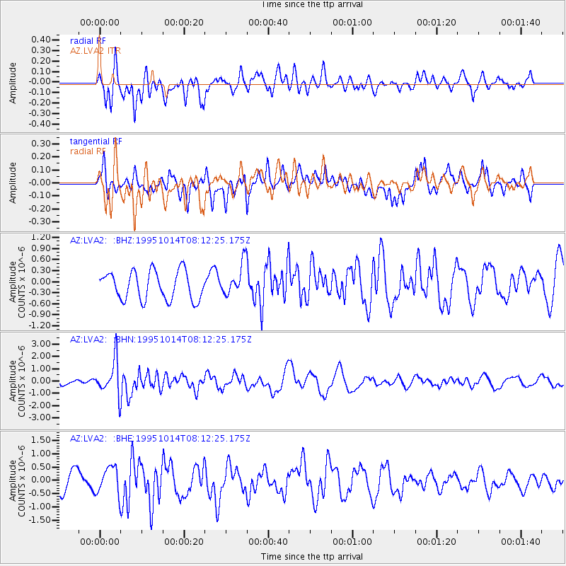
Signal To Noise
| Channel | StoN | STA | LTA |
| AZ:LVA2: :BHN:19951014T08:12:25.175Z | 5.398049 | 1.4612497E-6 | 2.7069962E-7 |
| AZ:LVA2: :BHE:19951014T08:12:25.175Z | 0.93951404 | 5.1360456E-7 | 5.466705E-7 |
| AZ:LVA2: :BHZ:19951014T08:12:25.175Z | 1.1851995 | 4.564747E-7 | 3.851459E-7 |
| Arrivals |
| Ps | |
| PpPs | |
| PsPs/PpSs | |


