You are here: Home > Network List > TA - USArray Transportable Network (new EarthScope stations) Stations List
> Station S30A Montezuma, KS, USA > Earthquake Result Viewer
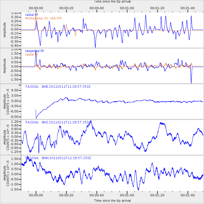
S30A Montezuma, KS, USA - Earthquake Result Viewer
*The percent match for this event was below the threshold and hence no stack was calculated.
| Earthquake location: |
Near East Coast Of Honshu, Japan |
| Earthquake latitude/longitude: |
36.6/141.8 |
| Earthquake time(UTC): |
2011/03/11 (070) 11:16:50 GMT |
| Earthquake Depth: |
37 km |
| Earthquake Magnitude: |
5.5 MB |
| Earthquake Catalog/Contributor: |
WHDF/NEIC |
|
| Network: |
TA USArray Transportable Network (new EarthScope stations) |
| Station: |
S30A Montezuma, KS, USA |
| Lat/Lon: |
37.64 N/100.46 W |
| Elevation: |
853 m |
|
| Distance: |
86.3 deg |
| Az: |
44.76 deg |
| Baz: |
314.477 deg |
| Ray Param: |
$rayparam |
*The percent match for this event was below the threshold and hence was not used in the summary stack. |
|
| Radial Match: |
65.88539 % |
| Radial Bump: |
400 |
| Transverse Match: |
47.033134 % |
| Transverse Bump: |
399 |
| SOD ConfigId: |
356183 |
| Insert Time: |
2011-08-14 23:37:00.454 +0000 |
| GWidth: |
2.5 |
| Max Bumps: |
400 |
| Tol: |
0.001 |
|
Signal To Noise
| Channel | StoN | STA | LTA |
| TA:S30A: :BHZ:20110311T11:28:57.250Z | 1.6379153 | 6.647405E-7 | 4.058455E-7 |
| TA:S30A: :BHN:20110311T11:28:57.250Z | 0.86559486 | 2.1583817E-6 | 2.493524E-6 |
| TA:S30A: :BHE:20110311T11:28:57.250Z | 0.9037894 | 2.8938227E-6 | 3.2018772E-6 |
| Arrivals |
| Ps | |
| PpPs | |
| PsPs/PpSs | |


