You are here: Home > Network List > TA - USArray Transportable Network (new EarthScope stations) Stations List
> Station L02D Cave Junction, OR, USA > Earthquake Result Viewer
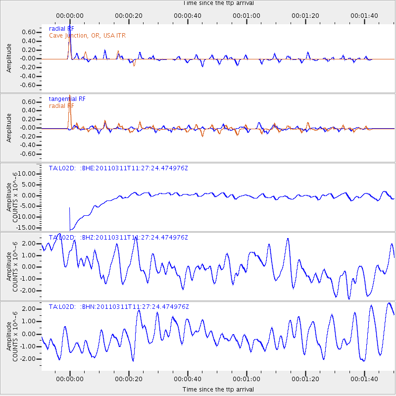
L02D Cave Junction, OR, USA - Earthquake Result Viewer
*The percent match for this event was below the threshold and hence no stack was calculated.
| Earthquake location: |
Near East Coast Of Honshu, Japan |
| Earthquake latitude/longitude: |
36.6/141.8 |
| Earthquake time(UTC): |
2011/03/11 (070) 11:16:50 GMT |
| Earthquake Depth: |
37 km |
| Earthquake Magnitude: |
5.5 MB |
| Earthquake Catalog/Contributor: |
WHDF/NEIC |
|
| Network: |
TA USArray Transportable Network (new EarthScope stations) |
| Station: |
L02D Cave Junction, OR, USA |
| Lat/Lon: |
42.16 N/123.60 W |
| Elevation: |
458 m |
|
| Distance: |
69.6 deg |
| Az: |
52.279 deg |
| Baz: |
301.152 deg |
| Ray Param: |
$rayparam |
*The percent match for this event was below the threshold and hence was not used in the summary stack. |
|
| Radial Match: |
27.141182 % |
| Radial Bump: |
151 |
| Transverse Match: |
53.31715 % |
| Transverse Bump: |
400 |
| SOD ConfigId: |
356183 |
| Insert Time: |
2011-08-14 23:54:29.345 +0000 |
| GWidth: |
2.5 |
| Max Bumps: |
400 |
| Tol: |
0.001 |
|
Signal To Noise
| Channel | StoN | STA | LTA |
| TA:L02D: :BHZ:20110311T11:27:24.474976Z | 0.7505769 | 4.8187317E-6 | 6.4200376E-6 |
| TA:L02D: :BHN:20110311T11:27:24.474976Z | 1.2507403 | 3.6829072E-6 | 2.9445816E-6 |
| TA:L02D: :BHE:20110311T11:27:24.474976Z | 1.0876409 | 5.467707E-6 | 5.027125E-6 |
| Arrivals |
| Ps | |
| PpPs | |
| PsPs/PpSs | |


