You are here: Home > Network List > TA - USArray Transportable Network (new EarthScope stations) Stations List
> Station 133A Hamilton Ranch, Breckenridge, TX, USA > Earthquake Result Viewer
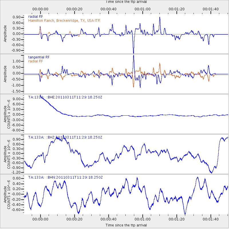
133A Hamilton Ranch, Breckenridge, TX, USA - Earthquake Result Viewer
*The percent match for this event was below the threshold and hence no stack was calculated.
| Earthquake location: |
Near East Coast Of Honshu, Japan |
| Earthquake latitude/longitude: |
36.6/141.8 |
| Earthquake time(UTC): |
2011/03/11 (070) 11:16:50 GMT |
| Earthquake Depth: |
37 km |
| Earthquake Magnitude: |
5.5 MB |
| Earthquake Catalog/Contributor: |
WHDF/NEIC |
|
| Network: |
TA USArray Transportable Network (new EarthScope stations) |
| Station: |
133A Hamilton Ranch, Breckenridge, TX, USA |
| Lat/Lon: |
32.61 N/98.92 W |
| Elevation: |
418 m |
|
| Distance: |
90.8 deg |
| Az: |
47.416 deg |
| Baz: |
315.431 deg |
| Ray Param: |
$rayparam |
*The percent match for this event was below the threshold and hence was not used in the summary stack. |
|
| Radial Match: |
74.40824 % |
| Radial Bump: |
365 |
| Transverse Match: |
70.81678 % |
| Transverse Bump: |
392 |
| SOD ConfigId: |
356183 |
| Insert Time: |
2011-08-14 23:55:54.359 +0000 |
| GWidth: |
2.5 |
| Max Bumps: |
400 |
| Tol: |
0.001 |
|
Signal To Noise
| Channel | StoN | STA | LTA |
| TA:133A: :BHZ:20110311T11:29:18.250Z | 0.4093835 | 1.827039E-7 | 4.4629033E-7 |
| TA:133A: :BHN:20110311T11:29:18.250Z | 0.77921695 | 4.6836288E-7 | 6.010687E-7 |
| TA:133A: :BHE:20110311T11:29:18.250Z | 0.83480126 | 3.0382457E-6 | 3.639484E-6 |
| Arrivals |
| Ps | |
| PpPs | |
| PsPs/PpSs | |


