You are here: Home > Network List > US - United States National Seismic Network Stations List
> Station MSO Missoula, Montana, USA > Earthquake Result Viewer
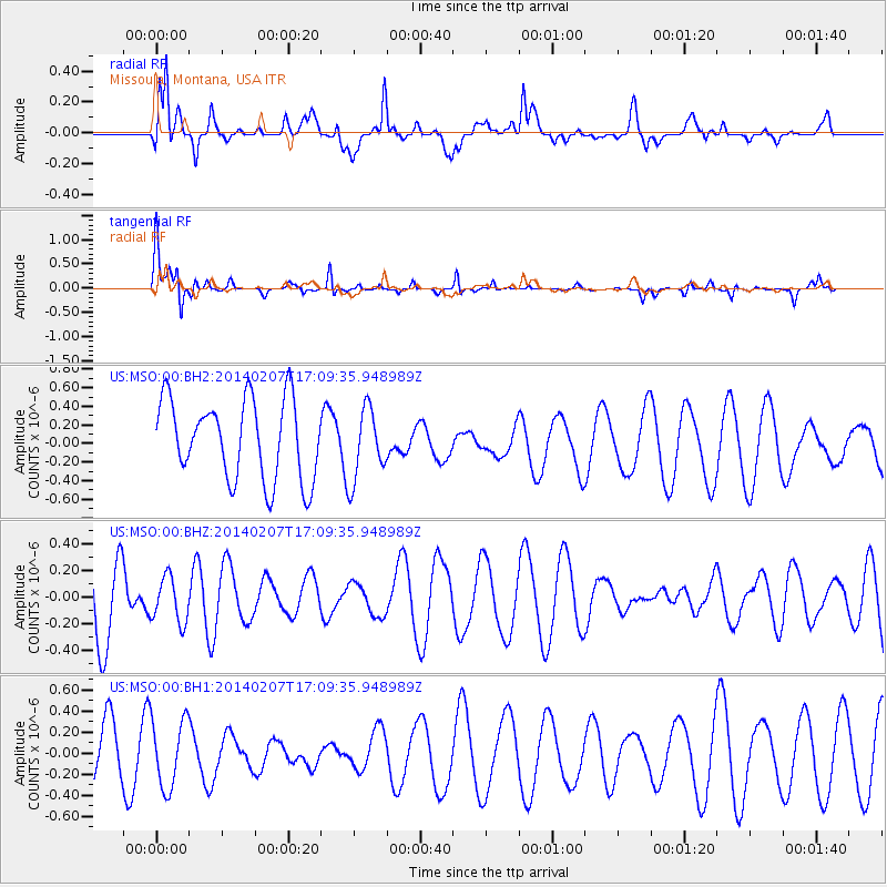
MSO Missoula, Montana, USA - Earthquake Result Viewer
*The percent match for this event was below the threshold and hence no stack was calculated.
| Earthquake location: |
Kermadec Islands, New Zealand |
| Earthquake latitude/longitude: |
-30.5/-177.9 |
| Earthquake time(UTC): |
2014/02/07 (038) 16:56:44 GMT |
| Earthquake Depth: |
46 km |
| Earthquake Magnitude: |
5.0 mb |
| Earthquake Catalog/Contributor: |
ISC/ISC |
|
| Network: |
US United States National Seismic Network |
| Station: |
MSO Missoula, Montana, USA |
| Lat/Lon: |
46.83 N/113.94 W |
| Elevation: |
1264 m |
|
| Distance: |
96.2 deg |
| Az: |
38.346 deg |
| Baz: |
231.218 deg |
| Ray Param: |
$rayparam |
*The percent match for this event was below the threshold and hence was not used in the summary stack. |
|
| Radial Match: |
62.443707 % |
| Radial Bump: |
400 |
| Transverse Match: |
75.85059 % |
| Transverse Bump: |
400 |
| SOD ConfigId: |
3390531 |
| Insert Time: |
2019-04-10 06:32:07.412 +0000 |
| GWidth: |
2.5 |
| Max Bumps: |
400 |
| Tol: |
0.001 |
|
Signal To Noise
| Channel | StoN | STA | LTA |
| US:MSO:00:BHZ:20140207T17:09:35.948989Z | 0.4880427 | 1.7052679E-7 | 3.4940956E-7 |
| US:MSO:00:BH1:20140207T17:09:35.948989Z | 1.2469226 | 3.2738828E-7 | 2.6255702E-7 |
| US:MSO:00:BH2:20140207T17:09:35.948989Z | 0.90240866 | 3.873289E-7 | 4.2921673E-7 |
| Arrivals |
| Ps | |
| PpPs | |
| PsPs/PpSs | |


