You are here: Home > Network List > TA - USArray Transportable Network (new EarthScope stations) Stations List
> Station Z36A Blue Ridge, TX, USA > Earthquake Result Viewer
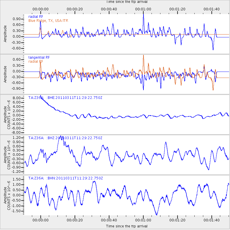
Z36A Blue Ridge, TX, USA - Earthquake Result Viewer
*The percent match for this event was below the threshold and hence no stack was calculated.
| Earthquake location: |
Near East Coast Of Honshu, Japan |
| Earthquake latitude/longitude: |
36.6/141.8 |
| Earthquake time(UTC): |
2011/03/11 (070) 11:16:50 GMT |
| Earthquake Depth: |
37 km |
| Earthquake Magnitude: |
5.5 MB |
| Earthquake Catalog/Contributor: |
WHDF/NEIC |
|
| Network: |
TA USArray Transportable Network (new EarthScope stations) |
| Station: |
Z36A Blue Ridge, TX, USA |
| Lat/Lon: |
33.27 N/96.43 W |
| Elevation: |
187 m |
|
| Distance: |
91.7 deg |
| Az: |
45.454 deg |
| Baz: |
316.818 deg |
| Ray Param: |
$rayparam |
*The percent match for this event was below the threshold and hence was not used in the summary stack. |
|
| Radial Match: |
60.85938 % |
| Radial Bump: |
313 |
| Transverse Match: |
63.71526 % |
| Transverse Bump: |
278 |
| SOD ConfigId: |
356183 |
| Insert Time: |
2011-08-15 00:11:51.860 +0000 |
| GWidth: |
2.5 |
| Max Bumps: |
400 |
| Tol: |
0.001 |
|
Signal To Noise
| Channel | StoN | STA | LTA |
| TA:Z36A: :BHZ:20110311T11:29:22.750Z | 0.582846 | 3.8210973E-7 | 6.55593E-7 |
| TA:Z36A: :BHN:20110311T11:29:22.750Z | 0.9926329 | 6.094958E-7 | 6.140193E-7 |
| TA:Z36A: :BHE:20110311T11:29:22.750Z | 1.1633261 | 3.0967003E-6 | 2.6619364E-6 |
| Arrivals |
| Ps | |
| PpPs | |
| PsPs/PpSs | |


