You are here: Home > Network List > TA - USArray Transportable Network (new EarthScope stations) Stations List
> Station L04D Klamath Falls, OR, USA > Earthquake Result Viewer
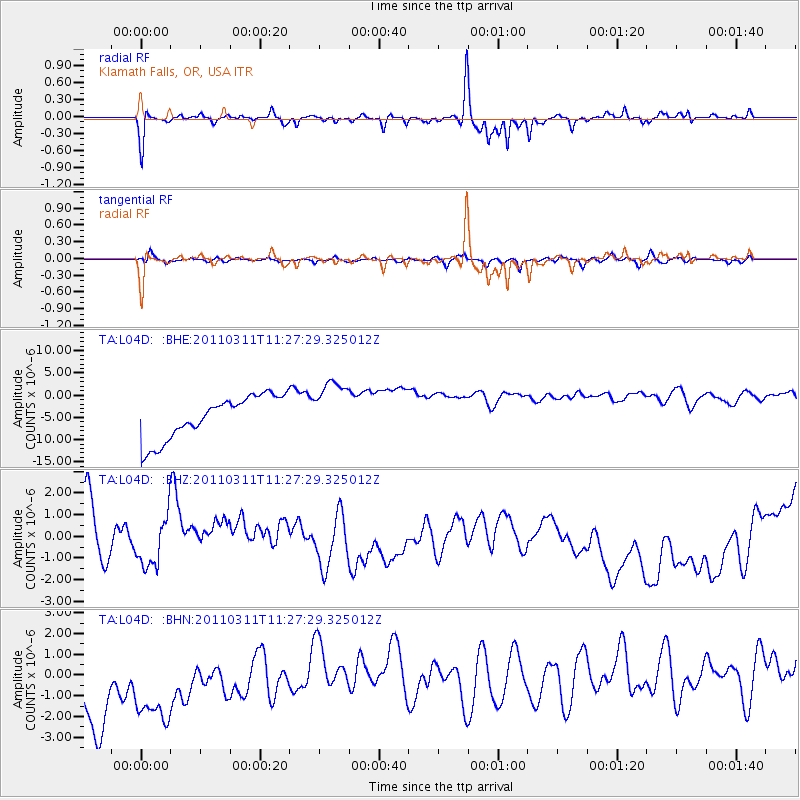
L04D Klamath Falls, OR, USA - Earthquake Result Viewer
*The percent match for this event was below the threshold and hence no stack was calculated.
| Earthquake location: |
Near East Coast Of Honshu, Japan |
| Earthquake latitude/longitude: |
36.6/141.8 |
| Earthquake time(UTC): |
2011/03/11 (070) 11:16:50 GMT |
| Earthquake Depth: |
37 km |
| Earthquake Magnitude: |
5.5 MB |
| Earthquake Catalog/Contributor: |
WHDF/NEIC |
|
| Network: |
TA USArray Transportable Network (new EarthScope stations) |
| Station: |
L04D Klamath Falls, OR, USA |
| Lat/Lon: |
42.22 N/122.30 W |
| Elevation: |
1437 m |
|
| Distance: |
70.3 deg |
| Az: |
51.688 deg |
| Baz: |
301.819 deg |
| Ray Param: |
$rayparam |
*The percent match for this event was below the threshold and hence was not used in the summary stack. |
|
| Radial Match: |
78.31035 % |
| Radial Bump: |
345 |
| Transverse Match: |
63.230606 % |
| Transverse Bump: |
400 |
| SOD ConfigId: |
356183 |
| Insert Time: |
2011-08-15 00:17:12.251 +0000 |
| GWidth: |
2.5 |
| Max Bumps: |
400 |
| Tol: |
0.001 |
|
Signal To Noise
| Channel | StoN | STA | LTA |
| TA:L04D: :BHZ:20110311T11:27:29.325012Z | 0.53240544 | 1.0546447E-6 | 1.9809052E-6 |
| TA:L04D: :BHN:20110311T11:27:29.325012Z | 1.050132 | 5.1788606E-6 | 4.931628E-6 |
| TA:L04D: :BHE:20110311T11:27:29.325012Z | 1.3199532 | 6.403485E-6 | 4.8512966E-6 |
| Arrivals |
| Ps | |
| PpPs | |
| PsPs/PpSs | |


