You are here: Home > Network List > TA - USArray Transportable Network (new EarthScope stations) Stations List
> Station H31A Wolsey, SD, USA > Earthquake Result Viewer
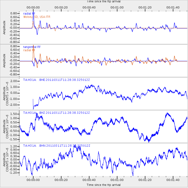
H31A Wolsey, SD, USA - Earthquake Result Viewer
*The percent match for this event was below the threshold and hence no stack was calculated.
| Earthquake location: |
Near East Coast Of Honshu, Japan |
| Earthquake latitude/longitude: |
36.6/141.8 |
| Earthquake time(UTC): |
2011/03/11 (070) 11:16:50 GMT |
| Earthquake Depth: |
37 km |
| Earthquake Magnitude: |
5.5 MB |
| Earthquake Catalog/Contributor: |
WHDF/NEIC |
|
| Network: |
TA USArray Transportable Network (new EarthScope stations) |
| Station: |
H31A Wolsey, SD, USA |
| Lat/Lon: |
44.48 N/98.48 W |
| Elevation: |
415 m |
|
| Distance: |
82.6 deg |
| Az: |
38.829 deg |
| Baz: |
315.204 deg |
| Ray Param: |
$rayparam |
*The percent match for this event was below the threshold and hence was not used in the summary stack. |
|
| Radial Match: |
44.602863 % |
| Radial Bump: |
289 |
| Transverse Match: |
37.297634 % |
| Transverse Bump: |
400 |
| SOD ConfigId: |
356183 |
| Insert Time: |
2011-08-15 00:21:10.854 +0000 |
| GWidth: |
2.5 |
| Max Bumps: |
400 |
| Tol: |
0.001 |
|
Signal To Noise
| Channel | StoN | STA | LTA |
| TA:H31A: :BHZ:20110311T11:28:38.325012Z | 2.2211692 | 1.2641545E-6 | 5.691393E-7 |
| TA:H31A: :BHN:20110311T11:28:38.325012Z | 1.687704 | 1.2652278E-6 | 7.4967403E-7 |
| TA:H31A: :BHE:20110311T11:28:38.325012Z | 1.3374497 | 8.8279245E-7 | 6.6005657E-7 |
| Arrivals |
| Ps | |
| PpPs | |
| PsPs/PpSs | |


