You are here: Home > Network List > TA - USArray Transportable Network (new EarthScope stations) Stations List
> Station B34A Aery, Baudette, MN, USA > Earthquake Result Viewer
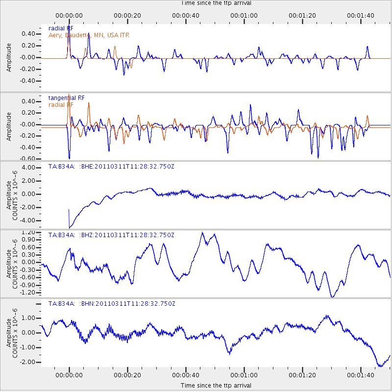
B34A Aery, Baudette, MN, USA - Earthquake Result Viewer
*The percent match for this event was below the threshold and hence no stack was calculated.
| Earthquake location: |
Near East Coast Of Honshu, Japan |
| Earthquake latitude/longitude: |
36.6/141.8 |
| Earthquake time(UTC): |
2011/03/11 (070) 11:16:50 GMT |
| Earthquake Depth: |
37 km |
| Earthquake Magnitude: |
5.5 MB |
| Earthquake Catalog/Contributor: |
WHDF/NEIC |
|
| Network: |
TA USArray Transportable Network (new EarthScope stations) |
| Station: |
B34A Aery, Baudette, MN, USA |
| Lat/Lon: |
48.49 N/94.65 W |
| Elevation: |
354 m |
|
| Distance: |
81.5 deg |
| Az: |
34.103 deg |
| Baz: |
317.317 deg |
| Ray Param: |
$rayparam |
*The percent match for this event was below the threshold and hence was not used in the summary stack. |
|
| Radial Match: |
60.023865 % |
| Radial Bump: |
376 |
| Transverse Match: |
60.32545 % |
| Transverse Bump: |
326 |
| SOD ConfigId: |
356183 |
| Insert Time: |
2011-08-15 00:24:12.224 +0000 |
| GWidth: |
2.5 |
| Max Bumps: |
400 |
| Tol: |
0.001 |
|
Signal To Noise
| Channel | StoN | STA | LTA |
| TA:B34A: :BHZ:20110311T11:28:32.750Z | 0.61652726 | 4.2050323E-7 | 6.820513E-7 |
| TA:B34A: :BHN:20110311T11:28:32.750Z | 1.207622 | 1.2631211E-6 | 1.0459574E-6 |
| TA:B34A: :BHE:20110311T11:28:32.750Z | 0.7500854 | 1.1422303E-6 | 1.5228003E-6 |
| Arrivals |
| Ps | |
| PpPs | |
| PsPs/PpSs | |


