You are here: Home > Network List > TA - USArray Transportable Network (new EarthScope stations) Stations List
> Station K37A Belmond, IA, USA > Earthquake Result Viewer
K37A Belmond, IA, USA - Earthquake Result Viewer

| Earthquake location: |
Near East Coast Of Honshu, Japan |
| Earthquake latitude/longitude: |
36.6/141.8 |
| Earthquake time(UTC): |
2011/03/11 (070) 11:16:50 GMT |
| Earthquake Depth: |
37 km |
| Earthquake Magnitude: |
5.5 MB |
| Earthquake Catalog/Contributor: |
WHDF/NEIC |
|
| Network: |
TA USArray Transportable Network (new EarthScope stations) |
| Station: |
K37A Belmond, IA, USA |
| Lat/Lon: |
42.77 N/93.64 W |
| Elevation: |
365 m |
|
| Distance: |
86.2 deg |
| Az: |
37.432 deg |
| Baz: |
318.395 deg |
| Ray Param: |
0.044156834 |
| Estimated Moho Depth: |
58.5 km |
| Estimated Crust Vp/Vs: |
2.00 |
| Assumed Crust Vp: |
6.53 km/s |
| Estimated Crust Vs: |
3.265 km/s |
| Estimated Crust Poisson's Ratio: |
0.33 |
|
| Radial Match: |
82.10632 % |
| Radial Bump: |
308 |
| Transverse Match: |
44.031754 % |
| Transverse Bump: |
301 |
| SOD ConfigId: |
356183 |
| Insert Time: |
2011-08-15 00:26:54.841 +0000 |
| GWidth: |
2.5 |
| Max Bumps: |
400 |
| Tol: |
0.001 |
|
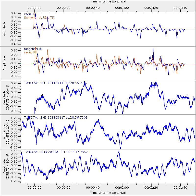
Signal To Noise
| Channel | StoN | STA | LTA |
| TA:K37A: :BHZ:20110311T11:28:56.750Z | 0.9496498 | 7.8335233E-7 | 8.248855E-7 |
| TA:K37A: :BHN:20110311T11:28:56.750Z | 2.4696367 | 1.0685387E-6 | 4.326704E-7 |
| TA:K37A: :BHE:20110311T11:28:56.750Z | 1.6814988 | 6.8127065E-7 | 4.0515675E-7 |
| Arrivals |
| Ps | 9.2 SECOND |
| PpPs | 26 SECOND |
| PsPs/PpSs | 35 SECOND |


