You are here: Home > Network List > TA - USArray Transportable Network (new EarthScope stations) Stations List
> Station M37A Trindle Farm, Earlham, IA, USA > Earthquake Result Viewer
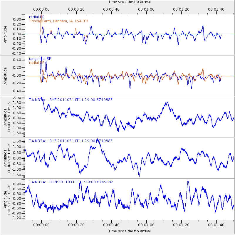
M37A Trindle Farm, Earlham, IA, USA - Earthquake Result Viewer
*The percent match for this event was below the threshold and hence no stack was calculated.
| Earthquake location: |
Near East Coast Of Honshu, Japan |
| Earthquake latitude/longitude: |
36.6/141.8 |
| Earthquake time(UTC): |
2011/03/11 (070) 11:16:50 GMT |
| Earthquake Depth: |
37 km |
| Earthquake Magnitude: |
5.5 MB |
| Earthquake Catalog/Contributor: |
WHDF/NEIC |
|
| Network: |
TA USArray Transportable Network (new EarthScope stations) |
| Station: |
M37A Trindle Farm, Earlham, IA, USA |
| Lat/Lon: |
41.40 N/94.06 W |
| Elevation: |
325 m |
|
| Distance: |
87.0 deg |
| Az: |
38.574 deg |
| Baz: |
318.183 deg |
| Ray Param: |
$rayparam |
*The percent match for this event was below the threshold and hence was not used in the summary stack. |
|
| Radial Match: |
48.29626 % |
| Radial Bump: |
400 |
| Transverse Match: |
57.84196 % |
| Transverse Bump: |
394 |
| SOD ConfigId: |
356183 |
| Insert Time: |
2011-08-15 00:28:15.292 +0000 |
| GWidth: |
2.5 |
| Max Bumps: |
400 |
| Tol: |
0.001 |
|
Signal To Noise
| Channel | StoN | STA | LTA |
| TA:M37A: :BHZ:20110311T11:29:00.674988Z | 0.6445226 | 5.1257126E-7 | 7.9527274E-7 |
| TA:M37A: :BHN:20110311T11:29:00.674988Z | 2.0659244 | 1.2703379E-6 | 6.1490044E-7 |
| TA:M37A: :BHE:20110311T11:29:00.674988Z | 1.6915301 | 8.2013906E-7 | 4.848504E-7 |
| Arrivals |
| Ps | |
| PpPs | |
| PsPs/PpSs | |


