You are here: Home > Network List > TA - USArray Transportable Network (new EarthScope stations) Stations List
> Station L36A Harm Buss Farm, Glidden, IA, USA > Earthquake Result Viewer
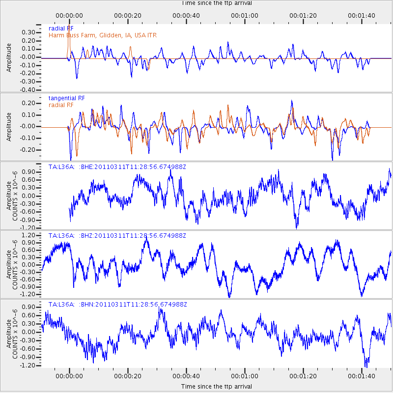
L36A Harm Buss Farm, Glidden, IA, USA - Earthquake Result Viewer
*The percent match for this event was below the threshold and hence no stack was calculated.
| Earthquake location: |
Near East Coast Of Honshu, Japan |
| Earthquake latitude/longitude: |
36.6/141.8 |
| Earthquake time(UTC): |
2011/03/11 (070) 11:16:50 GMT |
| Earthquake Depth: |
37 km |
| Earthquake Magnitude: |
5.5 MB |
| Earthquake Catalog/Contributor: |
WHDF/NEIC |
|
| Network: |
TA USArray Transportable Network (new EarthScope stations) |
| Station: |
L36A Harm Buss Farm, Glidden, IA, USA |
| Lat/Lon: |
42.10 N/94.67 W |
| Elevation: |
353 m |
|
| Distance: |
86.2 deg |
| Az: |
38.446 deg |
| Baz: |
317.771 deg |
| Ray Param: |
$rayparam |
*The percent match for this event was below the threshold and hence was not used in the summary stack. |
|
| Radial Match: |
56.74248 % |
| Radial Bump: |
400 |
| Transverse Match: |
56.727253 % |
| Transverse Bump: |
340 |
| SOD ConfigId: |
356183 |
| Insert Time: |
2011-08-15 00:29:14.678 +0000 |
| GWidth: |
2.5 |
| Max Bumps: |
400 |
| Tol: |
0.001 |
|
Signal To Noise
| Channel | StoN | STA | LTA |
| TA:L36A: :BHZ:20110311T11:28:56.674988Z | 1.2067472 | 8.547647E-7 | 7.083213E-7 |
| TA:L36A: :BHN:20110311T11:28:56.674988Z | 2.2604995 | 6.885431E-7 | 3.0459773E-7 |
| TA:L36A: :BHE:20110311T11:28:56.674988Z | 1.0945944 | 3.7141913E-7 | 3.3932125E-7 |
| Arrivals |
| Ps | |
| PpPs | |
| PsPs/PpSs | |


