You are here: Home > Network List > US - United States National Seismic Network Stations List
> Station AMTX Amarillo, Texas, USA > Earthquake Result Viewer
AMTX Amarillo, Texas, USA - Earthquake Result Viewer
*The percent match for this event was below the threshold and hence no stack was calculated.
| Earthquake location: |
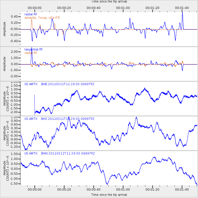
Near East Coast Of Honshu, Japan |
| Earthquake latitude/longitude: |
36.6/141.8 |
| Earthquake time(UTC): |
2011/03/11 (070) 11:16:50 GMT |
| Earthquake Depth: |
37 km |
| Earthquake Magnitude: |
5.5 MB |
| Earthquake Catalog/Contributor: |
WHDF/NEIC |
|
| Network: |
US United States National Seismic Network |
| Station: |
AMTX Amarillo, Texas, USA |
| Lat/Lon: |
34.53 N/101.41 W |
| Elevation: |
1010 m |
|
| Distance: |
87.9 deg |
| Az: |
47.52 deg |
| Baz: |
314.061 deg |
| Ray Param: |
$rayparam |
*The percent match for this event was below the threshold and hence was not used in the summary stack. |
|
| Radial Match: |
36.875053 % |
| Radial Bump: |
372 |
| Transverse Match: |
65.678604 % |
| Transverse Bump: |
390 |
| SOD ConfigId: |
356183 |
| Insert Time: |
2011-08-15 00:48:59.621 +0000 |
| GWidth: |
2.5 |
| Max Bumps: |
400 |
| Tol: |
0.001 |
|
Signal To Noise
| Channel | StoN | STA | LTA |
| US:AMTX: :BHZ:20110311T11:29:03.099976Z | 0.95384455 | 9.299545E-7 | 9.74954E-7 |
| US:AMTX: :BHN:20110311T11:29:03.099976Z | 0.9582386 | 1.2145046E-6 | 1.2674344E-6 |
| US:AMTX: :BHE:20110311T11:29:03.099976Z | 1.298023 | 9.0349357E-7 | 6.960536E-7 |
| Arrivals |
| Ps | |
| PpPs | |
| PsPs/PpSs | |


