You are here: Home > Network List > UW - Pacific Northwest Regional Seismic Network Stations List
> Station MRBL Marblemount, WA, USA > Earthquake Result Viewer
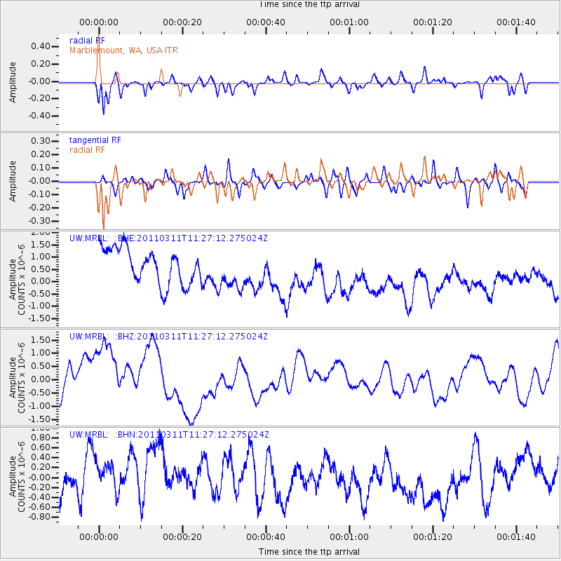
MRBL Marblemount, WA, USA - Earthquake Result Viewer
*The percent match for this event was below the threshold and hence no stack was calculated.
| Earthquake location: |
Near East Coast Of Honshu, Japan |
| Earthquake latitude/longitude: |
36.6/141.8 |
| Earthquake time(UTC): |
2011/03/11 (070) 11:16:50 GMT |
| Earthquake Depth: |
37 km |
| Earthquake Magnitude: |
5.5 MB |
| Earthquake Catalog/Contributor: |
WHDF/NEIC |
|
| Network: |
UW Pacific Northwest Regional Seismic Network |
| Station: |
MRBL Marblemount, WA, USA |
| Lat/Lon: |
48.52 N/121.48 W |
| Elevation: |
75 m |
|
| Distance: |
67.6 deg |
| Az: |
45.584 deg |
| Baz: |
300.208 deg |
| Ray Param: |
$rayparam |
*The percent match for this event was below the threshold and hence was not used in the summary stack. |
|
| Radial Match: |
66.70756 % |
| Radial Bump: |
400 |
| Transverse Match: |
47.483955 % |
| Transverse Bump: |
400 |
| SOD ConfigId: |
356183 |
| Insert Time: |
2011-08-15 00:53:46.163 +0000 |
| GWidth: |
2.5 |
| Max Bumps: |
400 |
| Tol: |
0.001 |
|
Signal To Noise
| Channel | StoN | STA | LTA |
| UW:MRBL: :BHZ:20110311T11:27:12.275024Z | 2.467461 | 1.8467507E-6 | 7.484417E-7 |
| UW:MRBL: :BHN:20110311T11:27:12.275024Z | 1.5790218 | 5.918605E-7 | 3.7482732E-7 |
| UW:MRBL: :BHE:20110311T11:27:12.275024Z | 1.1061021 | 7.8135116E-7 | 7.064006E-7 |
| Arrivals |
| Ps | |
| PpPs | |
| PsPs/PpSs | |


