You are here: Home > Network List > CN - Canadian National Seismograph Network Stations List
> Station INK INUVIK, NT, CANADA.ANADA > Earthquake Result Viewer
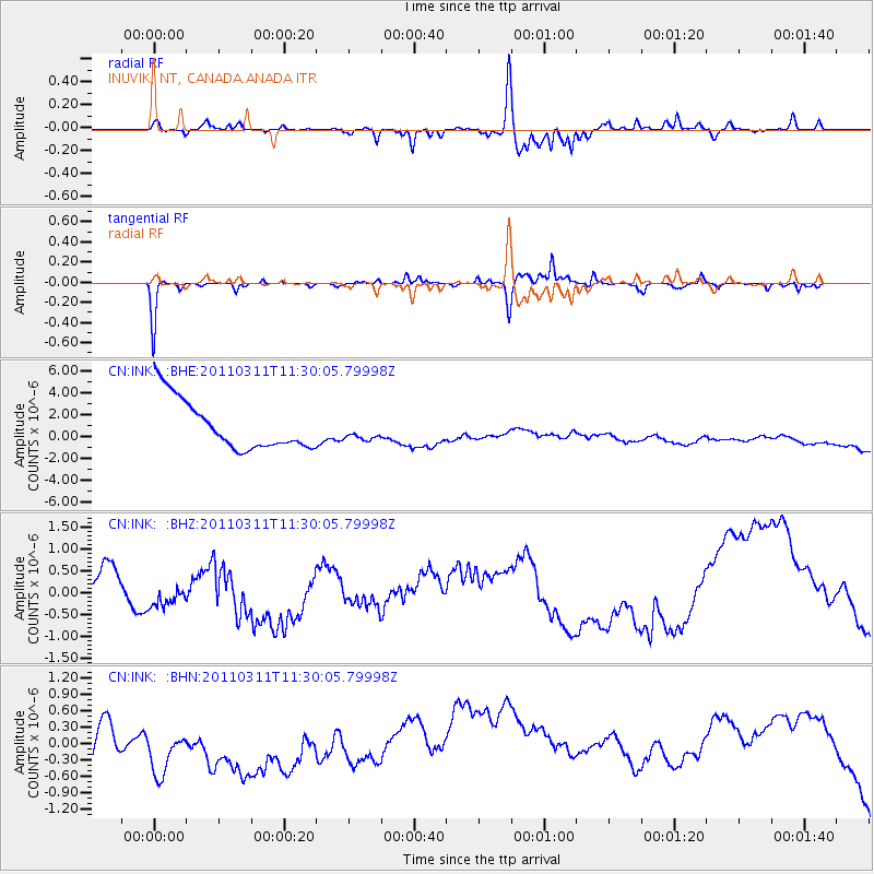
INK INUVIK, NT, CANADA.ANADA - Earthquake Result Viewer
*The percent match for this event was below the threshold and hence no stack was calculated.
| Earthquake location: |
Near East Coast Of Honshu, Japan |
| Earthquake latitude/longitude: |
35.7/140.9 |
| Earthquake time(UTC): |
2011/03/11 (070) 11:21:03 GMT |
| Earthquake Depth: |
35 km |
| Earthquake Magnitude: |
5.7 MB |
| Earthquake Catalog/Contributor: |
WHDF/NEIC |
|
| Network: |
CN Canadian National Seismograph Network |
| Station: |
INK INUVIK, NT, CANADA.ANADA |
| Lat/Lon: |
68.31 N/133.52 W |
| Elevation: |
40 m |
|
| Distance: |
55.8 deg |
| Az: |
26.638 deg |
| Baz: |
280.964 deg |
| Ray Param: |
$rayparam |
*The percent match for this event was below the threshold and hence was not used in the summary stack. |
|
| Radial Match: |
71.00713 % |
| Radial Bump: |
282 |
| Transverse Match: |
84.37833 % |
| Transverse Bump: |
186 |
| SOD ConfigId: |
356183 |
| Insert Time: |
2011-08-15 01:28:35.790 +0000 |
| GWidth: |
2.5 |
| Max Bumps: |
400 |
| Tol: |
0.001 |
|
Signal To Noise
| Channel | StoN | STA | LTA |
| CN:INK: :BHZ:20110311T11:30:05.79998Z | 0.21820599 | 1.6877381E-7 | 7.7346095E-7 |
| CN:INK: :BHN:20110311T11:30:05.79998Z | 0.9100852 | 7.078691E-7 | 7.778053E-7 |
| CN:INK: :BHE:20110311T11:30:05.79998Z | 0.39193648 | 8.8981295E-7 | 2.270299E-6 |
| Arrivals |
| Ps | |
| PpPs | |
| PsPs/PpSs | |


