You are here: Home > Network List > TA - USArray Transportable Network (new EarthScope stations) Stations List
> Station D58A Chemin du LacGrosbois, Trois-Rives, QC, CAN > Earthquake Result Viewer
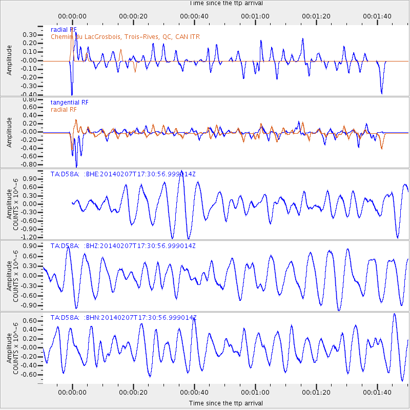
D58A Chemin du LacGrosbois, Trois-Rives, QC, CAN - Earthquake Result Viewer
*The percent match for this event was below the threshold and hence no stack was calculated.
| Earthquake location: |
Near East Coast Of Honshu, Japan |
| Earthquake latitude/longitude: |
37.5/141.4 |
| Earthquake time(UTC): |
2014/02/07 (038) 17:18:33 GMT |
| Earthquake Depth: |
57 km |
| Earthquake Magnitude: |
5.0 MW |
| Earthquake Catalog/Contributor: |
ISC/ISC |
|
| Network: |
TA USArray Transportable Network (new EarthScope stations) |
| Station: |
D58A Chemin du LacGrosbois, Trois-Rives, QC, CAN |
| Lat/Lon: |
47.10 N/72.88 W |
| Elevation: |
398 m |
|
| Distance: |
90.3 deg |
| Az: |
22.658 deg |
| Baz: |
333.375 deg |
| Ray Param: |
$rayparam |
*The percent match for this event was below the threshold and hence was not used in the summary stack. |
|
| Radial Match: |
57.287487 % |
| Radial Bump: |
400 |
| Transverse Match: |
82.226944 % |
| Transverse Bump: |
400 |
| SOD ConfigId: |
3390531 |
| Insert Time: |
2019-04-10 06:37:26.633 +0000 |
| GWidth: |
2.5 |
| Max Bumps: |
400 |
| Tol: |
0.001 |
|
Signal To Noise
| Channel | StoN | STA | LTA |
| TA:D58A: :BHZ:20140207T17:30:56.999014Z | 2.2628496 | 5.93275E-7 | 2.621805E-7 |
| TA:D58A: :BHN:20140207T17:30:56.999014Z | 0.78991044 | 2.660987E-7 | 3.36872E-7 |
| TA:D58A: :BHE:20140207T17:30:56.999014Z | 2.2204268 | 7.0250246E-7 | 3.1638174E-7 |
| Arrivals |
| Ps | |
| PpPs | |
| PsPs/PpSs | |


