You are here: Home > Network List > TA - USArray Transportable Network (new EarthScope stations) Stations List
> Station G59A Clarenceville, QC, USA > Earthquake Result Viewer
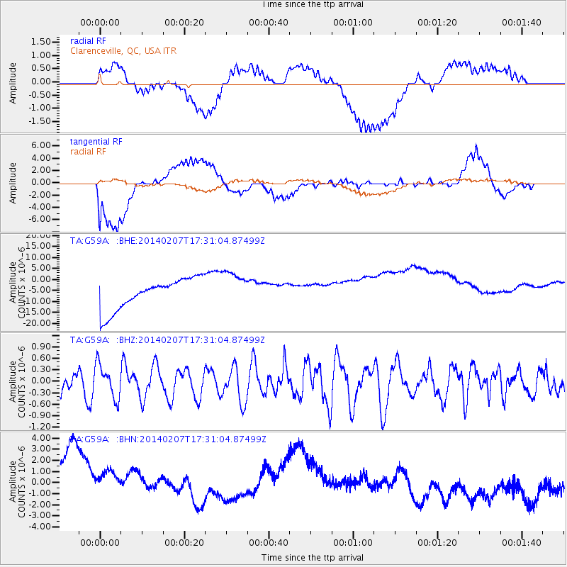
G59A Clarenceville, QC, USA - Earthquake Result Viewer
*The percent match for this event was below the threshold and hence no stack was calculated.
| Earthquake location: |
Near East Coast Of Honshu, Japan |
| Earthquake latitude/longitude: |
37.5/141.4 |
| Earthquake time(UTC): |
2014/02/07 (038) 17:18:33 GMT |
| Earthquake Depth: |
57 km |
| Earthquake Magnitude: |
5.0 MW |
| Earthquake Catalog/Contributor: |
ISC/ISC |
|
| Network: |
TA USArray Transportable Network (new EarthScope stations) |
| Station: |
G59A Clarenceville, QC, USA |
| Lat/Lon: |
45.08 N/73.18 W |
| Elevation: |
36 m |
|
| Distance: |
92.0 deg |
| Az: |
23.75 deg |
| Baz: |
333.139 deg |
| Ray Param: |
$rayparam |
*The percent match for this event was below the threshold and hence was not used in the summary stack. |
|
| Radial Match: |
43.936005 % |
| Radial Bump: |
400 |
| Transverse Match: |
36.32459 % |
| Transverse Bump: |
400 |
| SOD ConfigId: |
3390531 |
| Insert Time: |
2019-04-10 06:37:37.044 +0000 |
| GWidth: |
2.5 |
| Max Bumps: |
400 |
| Tol: |
0.001 |
|
Signal To Noise
| Channel | StoN | STA | LTA |
| TA:G59A: :BHZ:20140207T17:31:04.87499Z | 1.2953671 | 4.469817E-7 | 3.4506178E-7 |
| TA:G59A: :BHN:20140207T17:31:04.87499Z | 0.8430042 | 3.670793E-6 | 4.354418E-6 |
| TA:G59A: :BHE:20140207T17:31:04.87499Z | 1.1878259 | 8.2984325E-6 | 6.9862363E-6 |
| Arrivals |
| Ps | |
| PpPs | |
| PsPs/PpSs | |


