You are here: Home > Network List > AZ - ANZA Regional Network Stations List
> Station LVA2 AZ.LVA2 > Earthquake Result Viewer
LVA2 AZ.LVA2 - Earthquake Result Viewer
*The percent match for this event was below the threshold and hence no stack was calculated.
| Earthquake location: |
Near Coast Of Guatemala |
| Earthquake latitude/longitude: |
13.6/-91.0 |
| Earthquake time(UTC): |
2008/05/27 (148) 11:27:55 GMT |
| Earthquake Depth: |
26 km |
| Earthquake Magnitude: |
5.7 MW, 5.1 MS, 5.3 MB, 5.6 MW |
| Earthquake Catalog/Contributor: |
WHDF/NEIC |
|
| Network: |
AZ ANZA Regional Network |
| Station: |
LVA2 AZ.LVA2 |
| Lat/Lon: |
33.35 N/116.56 W |
| Elevation: |
1435 m |
|
| Distance: |
30.4 deg |
| Az: |
314.558 deg |
| Baz: |
124.138 deg |
| Ray Param: |
$rayparam |
*The percent match for this event was below the threshold and hence was not used in the summary stack. |
|
| Radial Match: |
65.16355 % |
| Radial Bump: |
400 |
| Transverse Match: |
66.28579 % |
| Transverse Bump: |
400 |
| SOD ConfigId: |
2504 |
| Insert Time: |
2010-02-26 19:57:15.094 +0000 |
| GWidth: |
2.5 |
| Max Bumps: |
400 |
| Tol: |
0.001 |
|
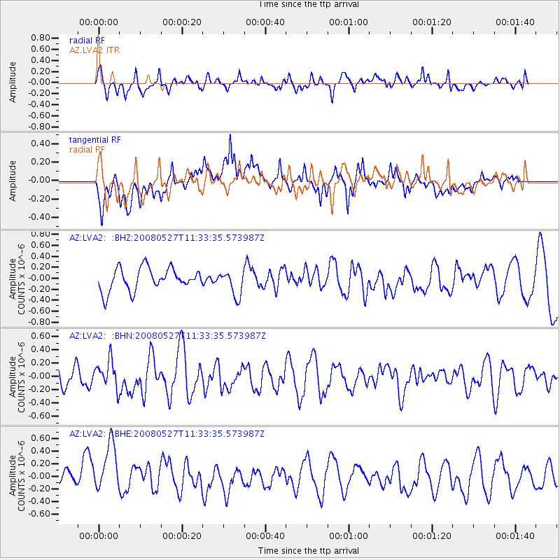
Signal To Noise
| Channel | StoN | STA | LTA |
| AZ:LVA2: :BHN:20080527T11:33:35.573987Z | 1.1713532 | 2.1431245E-7 | 1.8296141E-7 |
| AZ:LVA2: :BHE:20080527T11:33:35.573987Z | 3.413345 | 4.430729E-7 | 1.2980607E-7 |
| AZ:LVA2: :BHZ:20080527T11:33:35.573987Z | 1.1790613 | 2.3993476E-7 | 2.0349643E-7 |
| Arrivals |
| Ps | |
| PpPs | |
| PsPs/PpSs | |


