You are here: Home > Network List > TA - USArray Transportable Network (new EarthScope stations) Stations List
> Station R30A Dighton, KS, USA > Earthquake Result Viewer
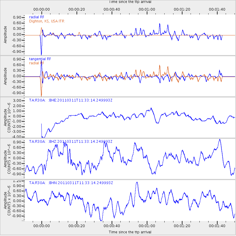
R30A Dighton, KS, USA - Earthquake Result Viewer
*The percent match for this event was below the threshold and hence no stack was calculated.
| Earthquake location: |
Near East Coast Of Honshu, Japan |
| Earthquake latitude/longitude: |
35.7/140.9 |
| Earthquake time(UTC): |
2011/03/11 (070) 11:21:03 GMT |
| Earthquake Depth: |
35 km |
| Earthquake Magnitude: |
5.7 MB |
| Earthquake Catalog/Contributor: |
WHDF/NEIC |
|
| Network: |
TA USArray Transportable Network (new EarthScope stations) |
| Station: |
R30A Dighton, KS, USA |
| Lat/Lon: |
38.28 N/100.28 W |
| Elevation: |
776 m |
|
| Distance: |
87.1 deg |
| Az: |
43.673 deg |
| Baz: |
314.41 deg |
| Ray Param: |
$rayparam |
*The percent match for this event was below the threshold and hence was not used in the summary stack. |
|
| Radial Match: |
63.946392 % |
| Radial Bump: |
397 |
| Transverse Match: |
45.186527 % |
| Transverse Bump: |
400 |
| SOD ConfigId: |
356183 |
| Insert Time: |
2011-08-15 02:04:12.183 +0000 |
| GWidth: |
2.5 |
| Max Bumps: |
400 |
| Tol: |
0.001 |
|
Signal To Noise
| Channel | StoN | STA | LTA |
| TA:R30A: :BHZ:20110311T11:33:14.249993Z | 0.8992845 | 6.173473E-7 | 6.864872E-7 |
| TA:R30A: :BHN:20110311T11:33:14.249993Z | 0.3574868 | 1.6506405E-7 | 4.617347E-7 |
| TA:R30A: :BHE:20110311T11:33:14.249993Z | 1.0352064 | 1.4672688E-6 | 1.4173683E-6 |
| Arrivals |
| Ps | |
| PpPs | |
| PsPs/PpSs | |


