You are here: Home > Network List > TA - USArray Transportable Network (new EarthScope stations) Stations List
> Station U34A Anderson Ranch, Garber, OK, USA > Earthquake Result Viewer
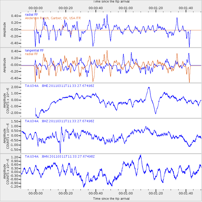
U34A Anderson Ranch, Garber, OK, USA - Earthquake Result Viewer
*The percent match for this event was below the threshold and hence no stack was calculated.
| Earthquake location: |
Near East Coast Of Honshu, Japan |
| Earthquake latitude/longitude: |
35.7/140.9 |
| Earthquake time(UTC): |
2011/03/11 (070) 11:21:03 GMT |
| Earthquake Depth: |
35 km |
| Earthquake Magnitude: |
5.7 MB |
| Earthquake Catalog/Contributor: |
WHDF/NEIC |
|
| Network: |
TA USArray Transportable Network (new EarthScope stations) |
| Station: |
U34A Anderson Ranch, Garber, OK, USA |
| Lat/Lon: |
36.44 N/97.54 W |
| Elevation: |
345 m |
|
| Distance: |
90.0 deg |
| Az: |
43.421 deg |
| Baz: |
316.061 deg |
| Ray Param: |
$rayparam |
*The percent match for this event was below the threshold and hence was not used in the summary stack. |
|
| Radial Match: |
57.295277 % |
| Radial Bump: |
400 |
| Transverse Match: |
42.016808 % |
| Transverse Bump: |
400 |
| SOD ConfigId: |
356183 |
| Insert Time: |
2011-08-15 02:16:11.350 +0000 |
| GWidth: |
2.5 |
| Max Bumps: |
400 |
| Tol: |
0.001 |
|
Signal To Noise
| Channel | StoN | STA | LTA |
| TA:U34A: :BHZ:20110311T11:33:27.67498Z | 1.5139514 | 5.6809E-7 | 3.7523662E-7 |
| TA:U34A: :BHN:20110311T11:33:27.67498Z | 1.0696565 | 3.34221E-7 | 3.124564E-7 |
| TA:U34A: :BHE:20110311T11:33:27.67498Z | 1.0762229 | 1.1242802E-6 | 1.0446536E-6 |
| Arrivals |
| Ps | |
| PpPs | |
| PsPs/PpSs | |


