You are here: Home > Network List > TA - USArray Transportable Network (new EarthScope stations) Stations List
> Station F34A Alexandria, MN, USA > Earthquake Result Viewer
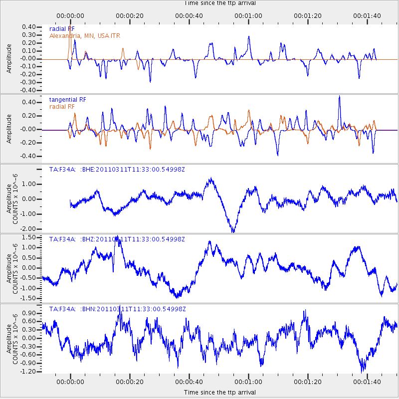
F34A Alexandria, MN, USA - Earthquake Result Viewer
*The percent match for this event was below the threshold and hence no stack was calculated.
| Earthquake location: |
Near East Coast Of Honshu, Japan |
| Earthquake latitude/longitude: |
35.7/140.9 |
| Earthquake time(UTC): |
2011/03/11 (070) 11:21:03 GMT |
| Earthquake Depth: |
35 km |
| Earthquake Magnitude: |
5.7 MB |
| Earthquake Catalog/Contributor: |
WHDF/NEIC |
|
| Network: |
TA USArray Transportable Network (new EarthScope stations) |
| Station: |
F34A Alexandria, MN, USA |
| Lat/Lon: |
45.80 N/95.26 W |
| Elevation: |
419 m |
|
| Distance: |
84.4 deg |
| Az: |
35.742 deg |
| Baz: |
317.179 deg |
| Ray Param: |
$rayparam |
*The percent match for this event was below the threshold and hence was not used in the summary stack. |
|
| Radial Match: |
54.746315 % |
| Radial Bump: |
314 |
| Transverse Match: |
63.756943 % |
| Transverse Bump: |
337 |
| SOD ConfigId: |
356183 |
| Insert Time: |
2011-08-15 02:53:50.953 +0000 |
| GWidth: |
2.5 |
| Max Bumps: |
400 |
| Tol: |
0.001 |
|
Signal To Noise
| Channel | StoN | STA | LTA |
| TA:F34A: :BHZ:20110311T11:33:00.54998Z | 0.75209004 | 2.8482404E-7 | 3.7871E-7 |
| TA:F34A: :BHN:20110311T11:33:00.54998Z | 3.8386524 | 9.422998E-7 | 2.454767E-7 |
| TA:F34A: :BHE:20110311T11:33:00.54998Z | 0.62914765 | 2.6130226E-7 | 4.1532738E-7 |
| Arrivals |
| Ps | |
| PpPs | |
| PsPs/PpSs | |


