You are here: Home > Network List > TA - USArray Transportable Network (new EarthScope stations) Stations List
> Station X39A Fountain Ranch, Mena, AR, USA > Earthquake Result Viewer
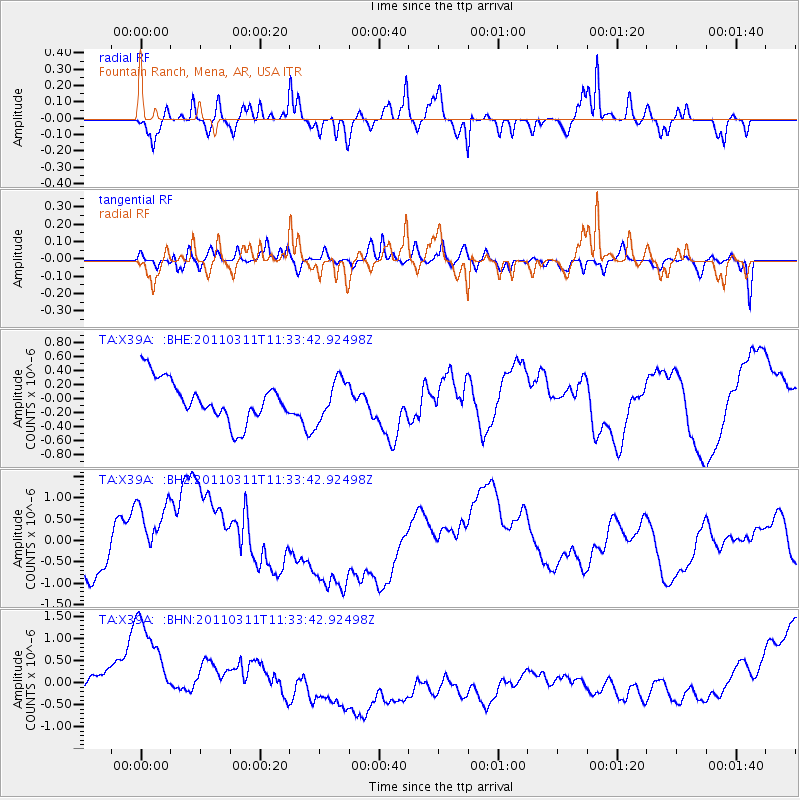
X39A Fountain Ranch, Mena, AR, USA - Earthquake Result Viewer
*The percent match for this event was below the threshold and hence no stack was calculated.
| Earthquake location: |
Near East Coast Of Honshu, Japan |
| Earthquake latitude/longitude: |
35.7/140.9 |
| Earthquake time(UTC): |
2011/03/11 (070) 11:21:03 GMT |
| Earthquake Depth: |
35 km |
| Earthquake Magnitude: |
5.7 MB |
| Earthquake Catalog/Contributor: |
WHDF/NEIC |
|
| Network: |
TA USArray Transportable Network (new EarthScope stations) |
| Station: |
X39A Fountain Ranch, Mena, AR, USA |
| Lat/Lon: |
34.51 N/94.11 W |
| Elevation: |
326 m |
|
| Distance: |
93.3 deg |
| Az: |
42.685 deg |
| Baz: |
318.059 deg |
| Ray Param: |
$rayparam |
*The percent match for this event was below the threshold and hence was not used in the summary stack. |
|
| Radial Match: |
52.85343 % |
| Radial Bump: |
340 |
| Transverse Match: |
44.489666 % |
| Transverse Bump: |
400 |
| SOD ConfigId: |
356183 |
| Insert Time: |
2011-08-15 03:05:56.070 +0000 |
| GWidth: |
2.5 |
| Max Bumps: |
400 |
| Tol: |
0.001 |
|
Signal To Noise
| Channel | StoN | STA | LTA |
| TA:X39A: :BHZ:20110311T11:33:42.92498Z | 3.5593333 | 1.1110933E-6 | 3.1216334E-7 |
| TA:X39A: :BHN:20110311T11:33:42.92498Z | 2.9521792 | 1.2109011E-6 | 4.1017196E-7 |
| TA:X39A: :BHE:20110311T11:33:42.92498Z | 0.993504 | 2.903501E-7 | 2.9224853E-7 |
| Arrivals |
| Ps | |
| PpPs | |
| PsPs/PpSs | |


