You are here: Home > Network List > AZ - ANZA Regional Network Stations List
> Station LVA2 AZ.LVA2 > Earthquake Result Viewer
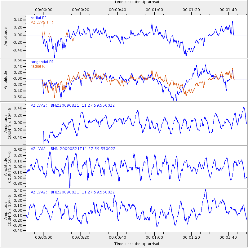
LVA2 AZ.LVA2 - Earthquake Result Viewer
*The percent match for this event was below the threshold and hence no stack was calculated.
| Earthquake location: |
Southeast Of Loyalty Islands |
| Earthquake latitude/longitude: |
-22.5/171.2 |
| Earthquake time(UTC): |
2009/08/21 (233) 11:15:39 GMT |
| Earthquake Depth: |
10 km |
| Earthquake Magnitude: |
5.7 MW, 5.2 MS, 5.2 MB, 5.6 MW |
| Earthquake Catalog/Contributor: |
WHDF/NEIC |
|
| Network: |
AZ ANZA Regional Network |
| Station: |
LVA2 AZ.LVA2 |
| Lat/Lon: |
33.35 N/116.56 W |
| Elevation: |
1435 m |
|
| Distance: |
88.4 deg |
| Az: |
52.868 deg |
| Baz: |
241.716 deg |
| Ray Param: |
$rayparam |
*The percent match for this event was below the threshold and hence was not used in the summary stack. |
|
| Radial Match: |
48.58101 % |
| Radial Bump: |
400 |
| Transverse Match: |
42.50331 % |
| Transverse Bump: |
400 |
| SOD ConfigId: |
2622 |
| Insert Time: |
2010-02-26 19:57:36.919 +0000 |
| GWidth: |
2.5 |
| Max Bumps: |
400 |
| Tol: |
0.001 |
|
Signal To Noise
| Channel | StoN | STA | LTA |
| AZ:LVA2: :BHN:20090821T11:27:59.55002Z | 2.1103637 | 1.4134717E-7 | 6.6977634E-8 |
| AZ:LVA2: :BHE:20090821T11:27:59.55002Z | 1.0065372 | 1.3614992E-7 | 1.3526567E-7 |
| AZ:LVA2: :BHZ:20090821T11:27:59.55002Z | 1.160668 | 2.4583133E-7 | 2.118016E-7 |
| Arrivals |
| Ps | |
| PpPs | |
| PsPs/PpSs | |


