You are here: Home > Network List > AZ - ANZA Regional Network Stations List
> Station LVA2 AZ.LVA2 > Earthquake Result Viewer
LVA2 AZ.LVA2 - Earthquake Result Viewer
*The percent match for this event was below the threshold and hence no stack was calculated.
| Earthquake location: |
Easter Island Region |
| Earthquake latitude/longitude: |
-29.9/-111.8 |
| Earthquake time(UTC): |
2009/09/10 (253) 19:46:03 GMT |
| Earthquake Depth: |
10 km |
| Earthquake Magnitude: |
5.5 MW, 5.4 MB |
| Earthquake Catalog/Contributor: |
WHDF/NEIC |
|
| Network: |
AZ ANZA Regional Network |
| Station: |
LVA2 AZ.LVA2 |
| Lat/Lon: |
33.35 N/116.56 W |
| Elevation: |
1435 m |
|
| Distance: |
63.1 deg |
| Az: |
355.554 deg |
| Baz: |
175.388 deg |
| Ray Param: |
$rayparam |
*The percent match for this event was below the threshold and hence was not used in the summary stack. |
|
| Radial Match: |
36.222923 % |
| Radial Bump: |
400 |
| Transverse Match: |
50.092705 % |
| Transverse Bump: |
400 |
| SOD ConfigId: |
2622 |
| Insert Time: |
2010-02-26 19:57:40.724 +0000 |
| GWidth: |
2.5 |
| Max Bumps: |
400 |
| Tol: |
0.001 |
|
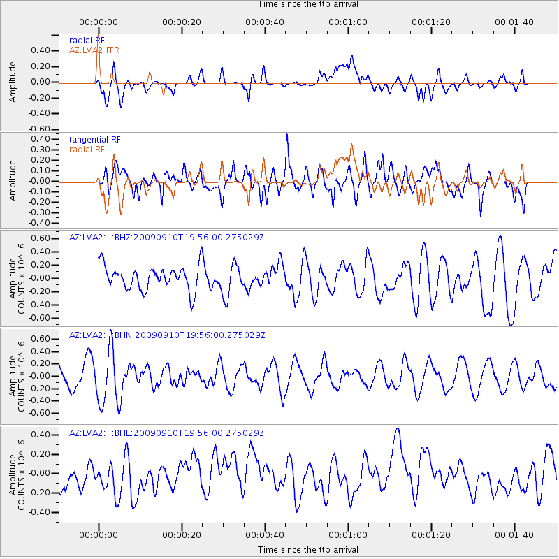
Signal To Noise
| Channel | StoN | STA | LTA |
| AZ:LVA2: :BHN:20090910T19:56:00.275029Z | 2.5862522 | 4.3945386E-7 | 1.6991918E-7 |
| AZ:LVA2: :BHE:20090910T19:56:00.275029Z | 1.1078475 | 2.3106564E-7 | 2.085717E-7 |
| AZ:LVA2: :BHZ:20090910T19:56:00.275029Z | 1.3632367 | 2.4217954E-7 | 1.7765039E-7 |
| Arrivals |
| Ps | |
| PpPs | |
| PsPs/PpSs | |


