You are here: Home > Network List > IU - Global Seismograph Network (GSN - IRIS/USGS) Stations List
> Station FURI Mt. Furi, Ethiopia > Earthquake Result Viewer
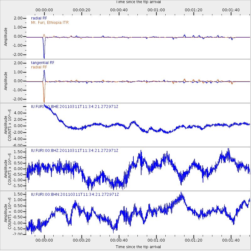
FURI Mt. Furi, Ethiopia - Earthquake Result Viewer
*The percent match for this event was below the threshold and hence no stack was calculated.
| Earthquake location: |
Off East Coast Of Honshu, Japan |
| Earthquake latitude/longitude: |
37.5/143.1 |
| Earthquake time(UTC): |
2011/03/11 (070) 11:21:29 GMT |
| Earthquake Depth: |
35 km |
| Earthquake Magnitude: |
5.8 MB |
| Earthquake Catalog/Contributor: |
WHDF/NEIC |
|
| Network: |
IU Global Seismograph Network (GSN - IRIS/USGS) |
| Station: |
FURI Mt. Furi, Ethiopia |
| Lat/Lon: |
8.90 N/38.68 E |
| Elevation: |
2570 m |
|
| Distance: |
95.9 deg |
| Az: |
285.818 deg |
| Baz: |
50.707 deg |
| Ray Param: |
$rayparam |
*The percent match for this event was below the threshold and hence was not used in the summary stack. |
|
| Radial Match: |
89.93835 % |
| Radial Bump: |
127 |
| Transverse Match: |
84.597015 % |
| Transverse Bump: |
253 |
| SOD ConfigId: |
356183 |
| Insert Time: |
2011-08-15 04:14:33.324 +0000 |
| GWidth: |
2.5 |
| Max Bumps: |
400 |
| Tol: |
0.001 |
|
Signal To Noise
| Channel | StoN | STA | LTA |
| IU:FURI:00:BHZ:20110311T11:34:21.272971Z | 0.75829965 | 2.0300938E-6 | 2.6771656E-6 |
| IU:FURI:00:BHN:20110311T11:34:21.272971Z | 0.7650171 | 4.125915E-6 | 5.393232E-6 |
| IU:FURI:00:BHE:20110311T11:34:21.272971Z | 0.5227208 | 1.2349036E-6 | 2.3624534E-6 |
| Arrivals |
| Ps | |
| PpPs | |
| PsPs/PpSs | |


