You are here: Home > Network List > TA - USArray Transportable Network (new EarthScope stations) Stations List
> Station N23A Red Feather Lakes, CO, USA > Earthquake Result Viewer
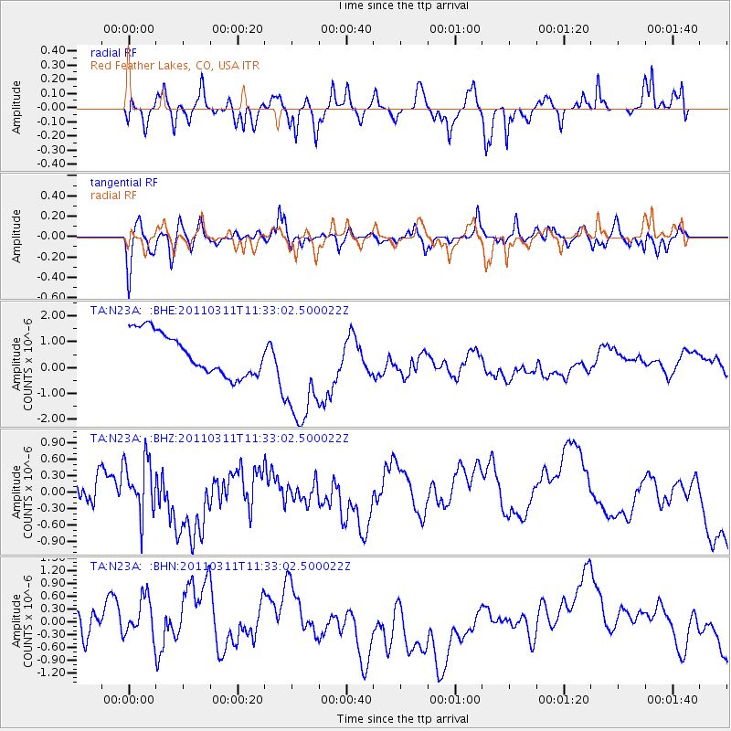
N23A Red Feather Lakes, CO, USA - Earthquake Result Viewer
*The percent match for this event was below the threshold and hence no stack was calculated.
| Earthquake location: |
Off East Coast Of Honshu, Japan |
| Earthquake latitude/longitude: |
37.5/143.1 |
| Earthquake time(UTC): |
2011/03/11 (070) 11:21:29 GMT |
| Earthquake Depth: |
35 km |
| Earthquake Magnitude: |
5.8 MB |
| Earthquake Catalog/Contributor: |
WHDF/NEIC |
|
| Network: |
TA USArray Transportable Network (new EarthScope stations) |
| Station: |
N23A Red Feather Lakes, CO, USA |
| Lat/Lon: |
40.89 N/105.94 W |
| Elevation: |
2458 m |
|
| Distance: |
79.6 deg |
| Az: |
46.019 deg |
| Baz: |
311.024 deg |
| Ray Param: |
$rayparam |
*The percent match for this event was below the threshold and hence was not used in the summary stack. |
|
| Radial Match: |
60.610176 % |
| Radial Bump: |
400 |
| Transverse Match: |
51.228447 % |
| Transverse Bump: |
400 |
| SOD ConfigId: |
356183 |
| Insert Time: |
2011-08-15 04:31:43.775 +0000 |
| GWidth: |
2.5 |
| Max Bumps: |
400 |
| Tol: |
0.001 |
|
Signal To Noise
| Channel | StoN | STA | LTA |
| TA:N23A: :BHZ:20110311T11:33:02.500022Z | 0.67252815 | 4.87325E-7 | 7.2461654E-7 |
| TA:N23A: :BHN:20110311T11:33:02.500022Z | 1.4949714 | 4.862382E-7 | 3.2524918E-7 |
| TA:N23A: :BHE:20110311T11:33:02.500022Z | 2.604085 | 2.1115823E-6 | 8.10873E-7 |
| Arrivals |
| Ps | |
| PpPs | |
| PsPs/PpSs | |


