You are here: Home > Network List > TA - USArray Transportable Network (new EarthScope stations) Stations List
> Station R31A Burdett, KS, USA > Earthquake Result Viewer
R31A Burdett, KS, USA - Earthquake Result Viewer
*The percent match for this event was below the threshold and hence no stack was calculated.
| Earthquake location: |
Off East Coast Of Honshu, Japan |
| Earthquake latitude/longitude: |
37.5/143.1 |
| Earthquake time(UTC): |
2011/03/11 (070) 11:21:29 GMT |
| Earthquake Depth: |
35 km |
| Earthquake Magnitude: |
5.8 MB |
| Earthquake Catalog/Contributor: |
WHDF/NEIC |
|
| Network: |
TA USArray Transportable Network (new EarthScope stations) |
| Station: |
R31A Burdett, KS, USA |
| Lat/Lon: |
38.29 N/99.53 W |
| Elevation: |
667 m |
|
| Distance: |
85.0 deg |
| Az: |
44.529 deg |
| Baz: |
314.902 deg |
| Ray Param: |
$rayparam |
*The percent match for this event was below the threshold and hence was not used in the summary stack. |
|
| Radial Match: |
64.05098 % |
| Radial Bump: |
312 |
| Transverse Match: |
40.667522 % |
| Transverse Bump: |
392 |
| SOD ConfigId: |
356183 |
| Insert Time: |
2011-08-15 04:36:43.176 +0000 |
| GWidth: |
2.5 |
| Max Bumps: |
400 |
| Tol: |
0.001 |
|
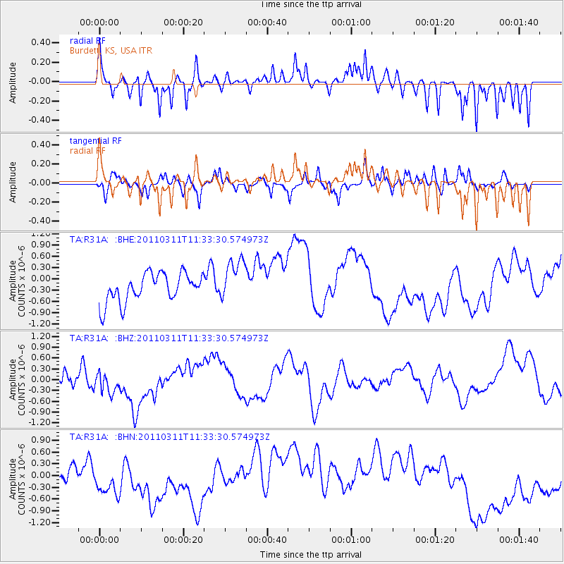
Signal To Noise
| Channel | StoN | STA | LTA |
| TA:R31A: :BHZ:20110311T11:33:30.574973Z | 0.7708672 | 3.278007E-7 | 4.2523627E-7 |
| TA:R31A: :BHN:20110311T11:33:30.574973Z | 2.5439782 | 5.9855074E-7 | 2.3528139E-7 |
| TA:R31A: :BHE:20110311T11:33:30.574973Z | 1.5372365 | 5.864007E-7 | 3.814642E-7 |
| Arrivals |
| Ps | |
| PpPs | |
| PsPs/PpSs | |


