You are here: Home > Network List > TA - USArray Transportable Network (new EarthScope stations) Stations List
> Station R32A Long Quarter, Great Bend, KS, USA > Earthquake Result Viewer
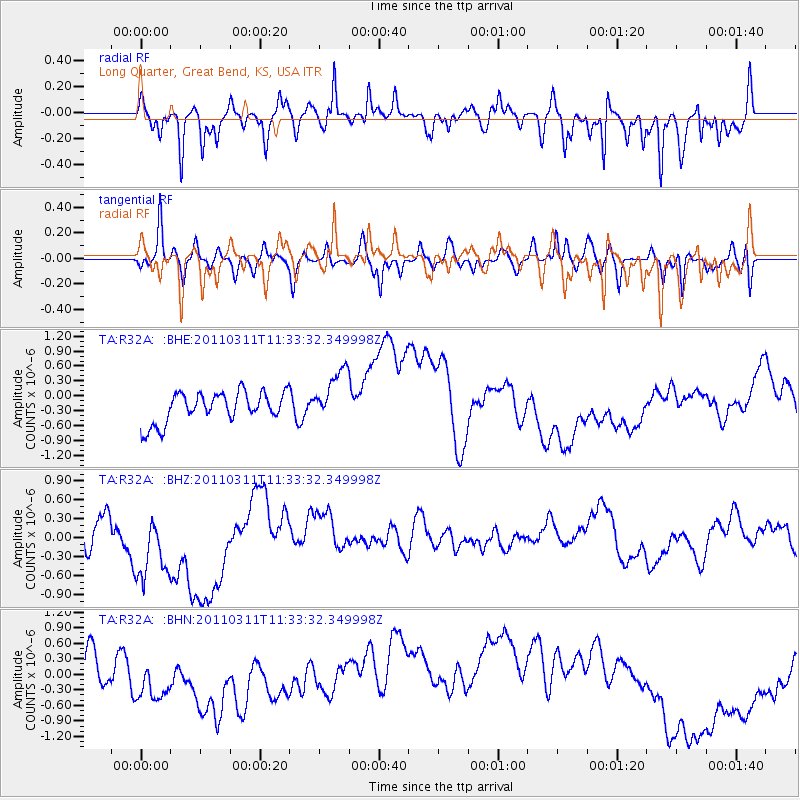
R32A Long Quarter, Great Bend, KS, USA - Earthquake Result Viewer
*The percent match for this event was below the threshold and hence no stack was calculated.
| Earthquake location: |
Off East Coast Of Honshu, Japan |
| Earthquake latitude/longitude: |
37.5/143.1 |
| Earthquake time(UTC): |
2011/03/11 (070) 11:21:29 GMT |
| Earthquake Depth: |
35 km |
| Earthquake Magnitude: |
5.8 MB |
| Earthquake Catalog/Contributor: |
WHDF/NEIC |
|
| Network: |
TA USArray Transportable Network (new EarthScope stations) |
| Station: |
R32A Long Quarter, Great Bend, KS, USA |
| Lat/Lon: |
38.42 N/98.71 W |
| Elevation: |
573 m |
|
| Distance: |
85.4 deg |
| Az: |
43.978 deg |
| Baz: |
315.36 deg |
| Ray Param: |
$rayparam |
*The percent match for this event was below the threshold and hence was not used in the summary stack. |
|
| Radial Match: |
63.1806 % |
| Radial Bump: |
305 |
| Transverse Match: |
63.62882 % |
| Transverse Bump: |
400 |
| SOD ConfigId: |
356183 |
| Insert Time: |
2011-08-15 04:53:10.311 +0000 |
| GWidth: |
2.5 |
| Max Bumps: |
400 |
| Tol: |
0.001 |
|
Signal To Noise
| Channel | StoN | STA | LTA |
| TA:R32A: :BHZ:20110311T11:33:32.349998Z | 1.7862747 | 7.356608E-7 | 4.1184083E-7 |
| TA:R32A: :BHN:20110311T11:33:32.349998Z | 1.4326942 | 5.0346347E-7 | 3.5141025E-7 |
| TA:R32A: :BHE:20110311T11:33:32.349998Z | 1.7624841 | 5.362199E-7 | 3.04241E-7 |
| Arrivals |
| Ps | |
| PpPs | |
| PsPs/PpSs | |


