You are here: Home > Network List > TA - USArray Transportable Network (new EarthScope stations) Stations List
> Station 833A Chaparral WMA, Artesia Wells, TX, USA > Earthquake Result Viewer
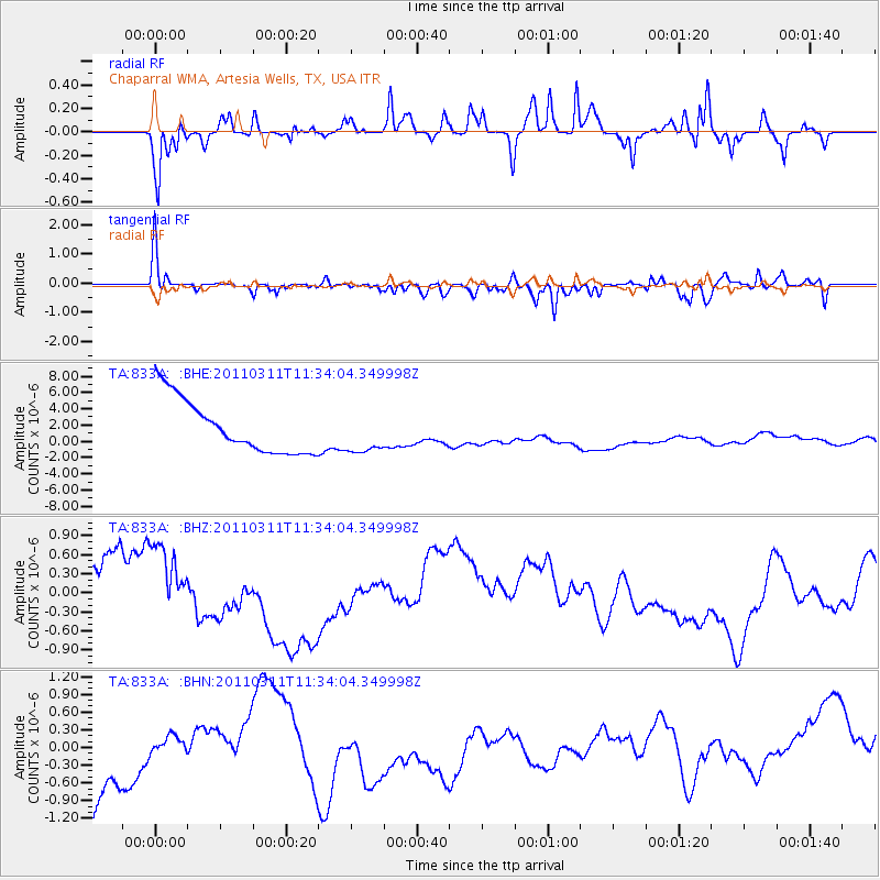
833A Chaparral WMA, Artesia Wells, TX, USA - Earthquake Result Viewer
*The percent match for this event was below the threshold and hence no stack was calculated.
| Earthquake location: |
Off East Coast Of Honshu, Japan |
| Earthquake latitude/longitude: |
37.5/143.1 |
| Earthquake time(UTC): |
2011/03/11 (070) 11:21:29 GMT |
| Earthquake Depth: |
35 km |
| Earthquake Magnitude: |
5.8 MB |
| Earthquake Catalog/Contributor: |
WHDF/NEIC |
|
| Network: |
TA USArray Transportable Network (new EarthScope stations) |
| Station: |
833A Chaparral WMA, Artesia Wells, TX, USA |
| Lat/Lon: |
28.32 N/99.39 W |
| Elevation: |
171 m |
|
| Distance: |
92.1 deg |
| Az: |
51.473 deg |
| Baz: |
315.146 deg |
| Ray Param: |
$rayparam |
*The percent match for this event was below the threshold and hence was not used in the summary stack. |
|
| Radial Match: |
53.276993 % |
| Radial Bump: |
301 |
| Transverse Match: |
69.097725 % |
| Transverse Bump: |
307 |
| SOD ConfigId: |
356183 |
| Insert Time: |
2011-08-15 04:58:02.276 +0000 |
| GWidth: |
2.5 |
| Max Bumps: |
400 |
| Tol: |
0.001 |
|
Signal To Noise
| Channel | StoN | STA | LTA |
| TA:833A: :BHZ:20110311T11:34:04.349998Z | 1.1546392 | 6.8920997E-7 | 5.9690507E-7 |
| TA:833A: :BHN:20110311T11:34:04.349998Z | 0.34947032 | 5.354977E-7 | 1.5323124E-6 |
| TA:833A: :BHE:20110311T11:34:04.349998Z | 0.7834165 | 2.5609959E-6 | 3.2690095E-6 |
| Arrivals |
| Ps | |
| PpPs | |
| PsPs/PpSs | |


