You are here: Home > Network List > TA - USArray Transportable Network (new EarthScope stations) Stations List
> Station 535A Dale, TX, USA > Earthquake Result Viewer
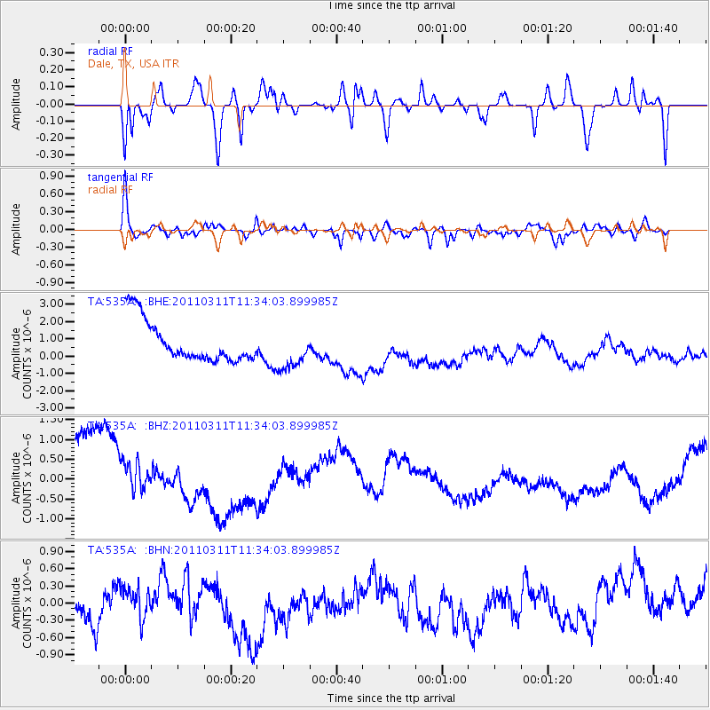
535A Dale, TX, USA - Earthquake Result Viewer
*The percent match for this event was below the threshold and hence no stack was calculated.
| Earthquake location: |
Off East Coast Of Honshu, Japan |
| Earthquake latitude/longitude: |
37.5/143.1 |
| Earthquake time(UTC): |
2011/03/11 (070) 11:21:29 GMT |
| Earthquake Depth: |
35 km |
| Earthquake Magnitude: |
5.8 MB |
| Earthquake Catalog/Contributor: |
WHDF/NEIC |
|
| Network: |
TA USArray Transportable Network (new EarthScope stations) |
| Station: |
535A Dale, TX, USA |
| Lat/Lon: |
30.03 N/97.57 W |
| Elevation: |
170 m |
|
| Distance: |
92.0 deg |
| Az: |
49.143 deg |
| Baz: |
316.116 deg |
| Ray Param: |
$rayparam |
*The percent match for this event was below the threshold and hence was not used in the summary stack. |
|
| Radial Match: |
52.31387 % |
| Radial Bump: |
400 |
| Transverse Match: |
67.96556 % |
| Transverse Bump: |
400 |
| SOD ConfigId: |
356183 |
| Insert Time: |
2011-08-15 04:59:02.588 +0000 |
| GWidth: |
2.5 |
| Max Bumps: |
400 |
| Tol: |
0.001 |
|
Signal To Noise
| Channel | StoN | STA | LTA |
| TA:535A: :BHZ:20110311T11:34:03.899985Z | 0.49243858 | 5.8549415E-7 | 1.1889689E-6 |
| TA:535A: :BHN:20110311T11:34:03.899985Z | 0.6619854 | 5.523271E-7 | 8.343493E-7 |
| TA:535A: :BHE:20110311T11:34:03.899985Z | 0.97904193 | 1.1665886E-6 | 1.1915614E-6 |
| Arrivals |
| Ps | |
| PpPs | |
| PsPs/PpSs | |


