You are here: Home > Network List > AZ - ANZA Regional Network Stations List
> Station MONP AZ.MONP > Earthquake Result Viewer
MONP AZ.MONP - Earthquake Result Viewer
| Earthquake location: |
Near Coast Of Northern Chile |
| Earthquake latitude/longitude: |
-21.7/-70.1 |
| Earthquake time(UTC): |
2001/08/28 (240) 06:56:09 GMT |
| Earthquake Depth: |
66 km |
| Earthquake Magnitude: |
5.8 MB, 5.9 MW, 5.8 MW |
| Earthquake Catalog/Contributor: |
WHDF/NEIC |
|
| Network: |
AZ ANZA Regional Network |
| Station: |
MONP AZ.MONP |
| Lat/Lon: |
32.89 N/116.42 W |
| Elevation: |
1920 m |
|
| Distance: |
70.0 deg |
| Az: |
319.66 deg |
| Baz: |
134.323 deg |
| Ray Param: |
0.05510428 |
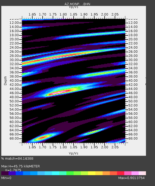
| Estimated Moho Depth: |
45.75 km |
| Estimated Crust Vp/Vs: |
1.77 |
| Assumed Crust Vp: |
6.264 km/s |
| Estimated Crust Vs: |
3.544 km/s |
| Estimated Crust Poisson's Ratio: |
0.26 |
|
| Radial Match: |
84.16388 % |
| Radial Bump: |
400 |
| Transverse Match: |
74.145134 % |
| Transverse Bump: |
400 |
| SOD ConfigId: |
32974 |
| Insert Time: |
2010-02-26 19:57:59.692 +0000 |
| GWidth: |
2.5 |
| Max Bumps: |
400 |
| Tol: |
0.001 |
|
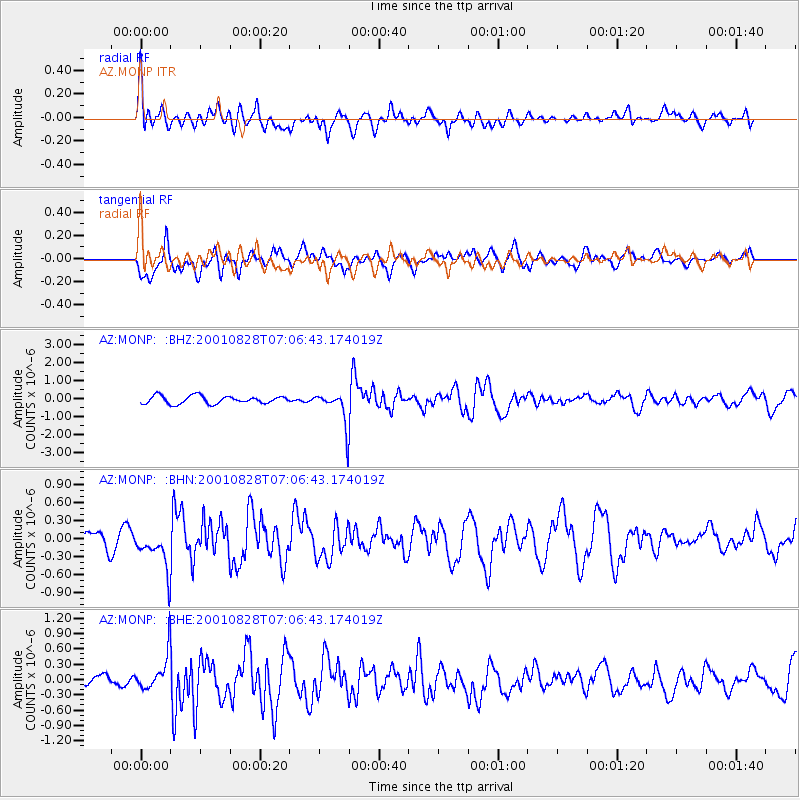
Signal To Noise
| Channel | StoN | STA | LTA |
| AZ:MONP: :BHN:20010828T07:06:43.174019Z | 2.5613039 | 3.3039893E-7 | 1.2899639E-7 |
| AZ:MONP: :BHE:20010828T07:06:43.174019Z | 1.8154854 | 3.4608567E-7 | 1.9062983E-7 |
| AZ:MONP: :BHZ:20010828T07:06:43.174019Z | 4.4312363 | 9.4531094E-7 | 2.1332895E-7 |
| Arrivals |
| Ps | 5.8 SECOND |
| PpPs | 20 SECOND |
| PsPs/PpSs | 25 SECOND |


