You are here: Home > Network List > AZ - ANZA Regional Network Stations List
> Station MONP AZ.MONP > Earthquake Result Viewer
MONP AZ.MONP - Earthquake Result Viewer
| Earthquake location: |
Western Honshu, Japan |
| Earthquake latitude/longitude: |
34.1/132.5 |
| Earthquake time(UTC): |
2001/03/24 (083) 06:27:53 GMT |
| Earthquake Depth: |
50 km |
| Earthquake Magnitude: |
6.4 MB, 6.5 MS, 6.8 MW, 6.4 ME |
| Earthquake Catalog/Contributor: |
WHDF/NEIC |
|
| Network: |
AZ ANZA Regional Network |
| Station: |
MONP AZ.MONP |
| Lat/Lon: |
32.89 N/116.42 W |
| Elevation: |
1920 m |
|
| Distance: |
87.1 deg |
| Az: |
51.832 deg |
| Baz: |
309.143 deg |
| Ray Param: |
0.043486923 |
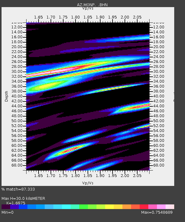
| Estimated Moho Depth: |
30.0 km |
| Estimated Crust Vp/Vs: |
1.70 |
| Assumed Crust Vp: |
6.264 km/s |
| Estimated Crust Vs: |
3.69 km/s |
| Estimated Crust Poisson's Ratio: |
0.23 |
|
| Radial Match: |
87.333 % |
| Radial Bump: |
336 |
| Transverse Match: |
66.75382 % |
| Transverse Bump: |
400 |
| SOD ConfigId: |
4714 |
| Insert Time: |
2010-02-26 19:58:05.818 +0000 |
| GWidth: |
2.5 |
| Max Bumps: |
400 |
| Tol: |
0.001 |
|
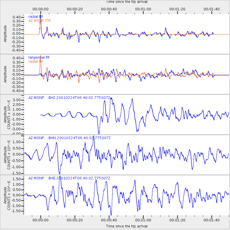
Signal To Noise
| Channel | StoN | STA | LTA |
| AZ:MONP: :BHN:20010324T06:40:02.775007Z | 3.3795693 | 5.386258E-7 | 1.5937705E-7 |
| AZ:MONP: :BHE:20010324T06:40:02.775007Z | 2.481353 | 5.321941E-7 | 2.144774E-7 |
| AZ:MONP: :BHZ:20010324T06:40:02.775007Z | 5.152565 | 1.6175971E-6 | 3.1394018E-7 |
| Arrivals |
| Ps | 3.4 SECOND |
| PpPs | 13 SECOND |
| PsPs/PpSs | 16 SECOND |


