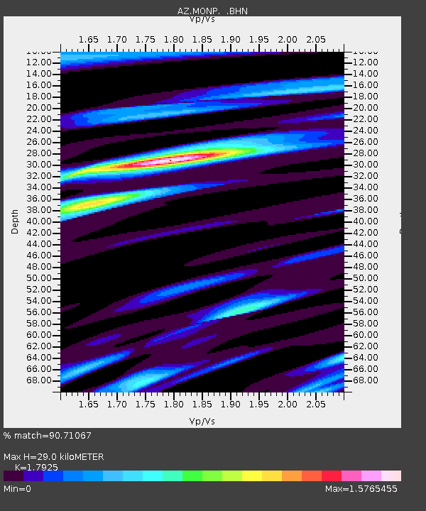
MONP AZ.MONP - Earthquake Result Viewer
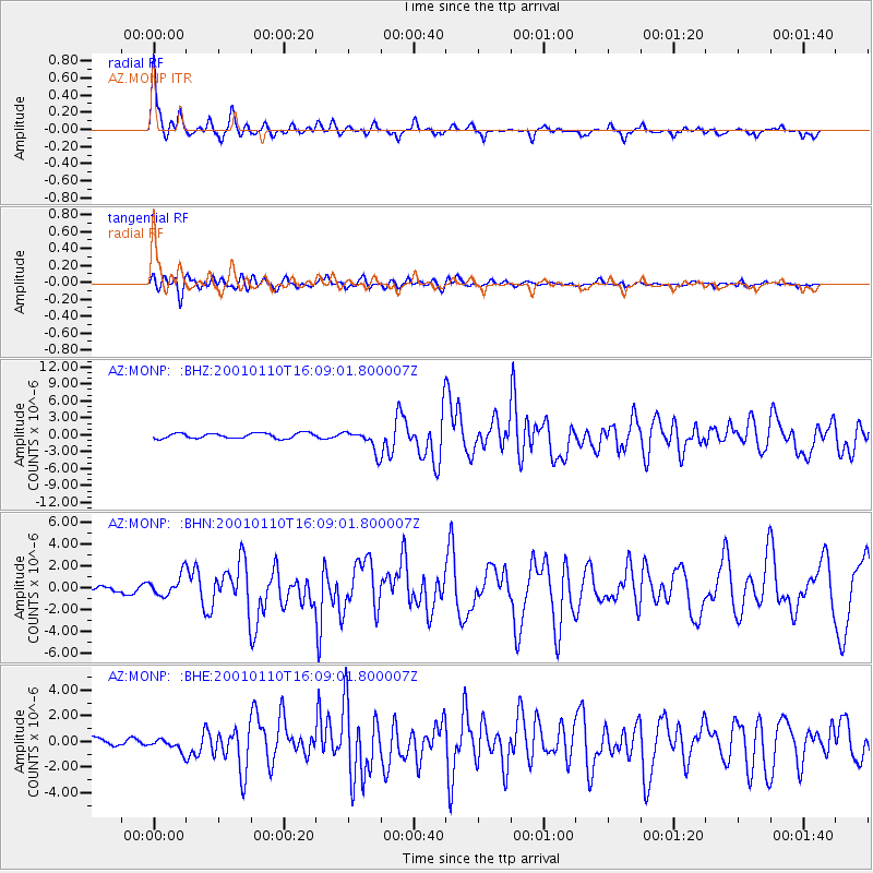
Earthquake location: Kodiak Island Region, Alaska
Earthquake latitude/longitude: 57.1/-153.2
Earthquake time(UTC): 2001/01/10 (010) 16:02:44 GMT
Earthquake Depth: 33 km
Earthquake Magnitude: 6.2 MB, 6.8 MS, 7.1 MW, 6.8 ML
Earthquake Catalog/Contributor: WHDF/NEIC
Network: AZ ANZA Regional Network
Station: MONP AZ.MONP
Lat/Lon: 32.89 N/116.42 W
Elevation: 1920 m
Distance: 34.8 deg
Az: 118.125 deg
Baz: 325.082 deg
Ray Param: 0.07747387
Estimated Moho Depth: 29.0 km
Estimated Crust Vp/Vs: 1.79
Assumed Crust Vp: 6.264 km/s
Estimated Crust Vs: 3.494 km/s
Estimated Crust Poisson's Ratio: 0.27
Radial Match: 90.71067 %
Radial Bump: 307
Transverse Match: 78.572105 %
Transverse Bump: 400
SOD ConfigId: 3744
Insert Time: 2010-02-26 19:58:08.904 +0000
GWidth: 2.5
Max Bumps: 400
Tol: 0.001

Signal To Noise

ChannelStoNSTALTA
AZ:MONP: :BHN:20010110T16:09:01.800007Z4.3663829.868426E-72.2600922E-7
AZ:MONP: :BHE:20010110T16:09:01.800007Z1.18312794.7089978E-73.980126E-7
AZ:MONP: :BHZ:20010110T16:09:01.800007Z4.16863351.912596E-64.5880643E-7
Arrivals
Ps3.9 SECOND
PpPs12 SECOND
PsPs/PpSs16 SECOND