You are here: Home > Network List > AZ - ANZA Regional Network Stations List
> Station MONP AZ.MONP > Earthquake Result Viewer
MONP AZ.MONP - Earthquake Result Viewer
| Earthquake location: |
Kermadec Islands, New Zealand |
| Earthquake latitude/longitude: |
-29.7/-178.6 |
| Earthquake time(UTC): |
2001/06/03 (154) 02:41:57 GMT |
| Earthquake Depth: |
178 km |
| Earthquake Magnitude: |
6.8 MB, 7.2 MW, 7.1 MW |
| Earthquake Catalog/Contributor: |
WHDF/NEIC |
|
| Network: |
AZ ANZA Regional Network |
| Station: |
MONP AZ.MONP |
| Lat/Lon: |
32.89 N/116.42 W |
| Elevation: |
1920 m |
|
| Distance: |
85.7 deg |
| Az: |
48.282 deg |
| Baz: |
230.548 deg |
| Ray Param: |
0.044178464 |
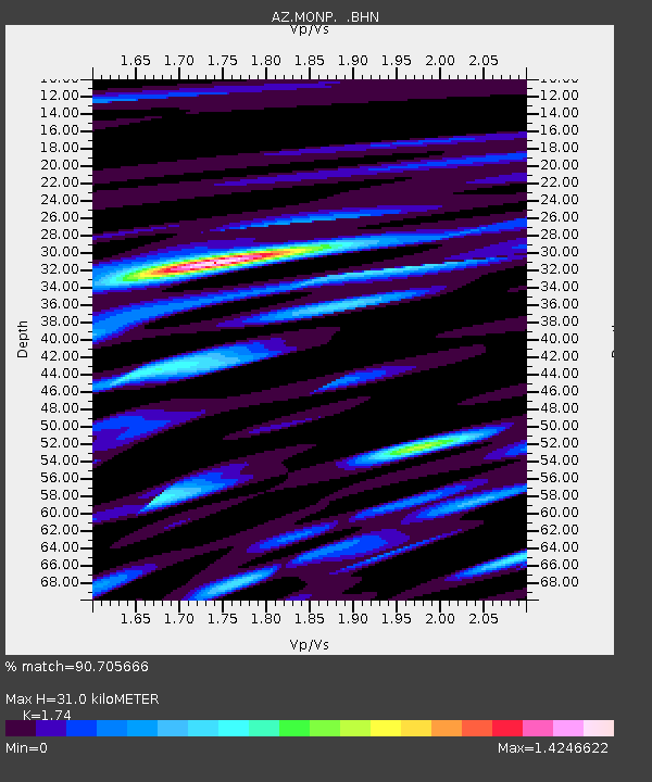
| Estimated Moho Depth: |
31.0 km |
| Estimated Crust Vp/Vs: |
1.74 |
| Assumed Crust Vp: |
6.264 km/s |
| Estimated Crust Vs: |
3.6 km/s |
| Estimated Crust Poisson's Ratio: |
0.25 |
|
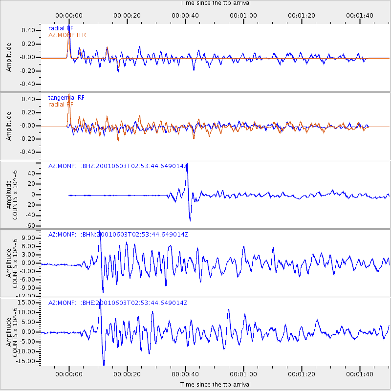
| Radial Match: |
90.705666 % |
| Radial Bump: |
391 |
| Transverse Match: |
89.68854 % |
| Transverse Bump: |
400 |
| SOD ConfigId: |
4714 |
| Insert Time: |
2010-02-26 19:58:12.417 +0000 |
| GWidth: |
2.5 |
| Max Bumps: |
400 |
| Tol: |
0.001 |
|
Signal To Noise
| Channel | StoN | STA | LTA |
| AZ:MONP: :BHN:20010603T02:53:44.649014Z | 1.6274879 | 6.980445E-7 | 4.289092E-7 |
| AZ:MONP: :BHE:20010603T02:53:44.649014Z | 1.1183594 | 3.714614E-7 | 3.321485E-7 |
| AZ:MONP: :BHZ:20010603T02:53:44.649014Z | 8.401788 | 1.1231872E-6 | 1.3368431E-7 |
| Arrivals |
| Ps | 3.7 SECOND |
| PpPs | 13 SECOND |
| PsPs/PpSs | 17 SECOND |


