You are here: Home > Network List > AZ - ANZA Regional Network Stations List
> Station MONP AZ.MONP > Earthquake Result Viewer
MONP AZ.MONP - Earthquake Result Viewer
| Earthquake location: |
Solomon Islands |
| Earthquake latitude/longitude: |
-9.6/159.5 |
| Earthquake time(UTC): |
2001/12/23 (357) 22:52:54 GMT |
| Earthquake Depth: |
16 km |
| Earthquake Magnitude: |
6.2 MB, 7.0 MS, 6.8 MW, 6.7 MW |
| Earthquake Catalog/Contributor: |
WHDF/NEIC |
|
| Network: |
AZ ANZA Regional Network |
| Station: |
MONP AZ.MONP |
| Lat/Lon: |
32.89 N/116.42 W |
| Elevation: |
1920 m |
|
| Distance: |
90.2 deg |
| Az: |
56.805 deg |
| Baz: |
258.763 deg |
| Ray Param: |
0.04168882 |
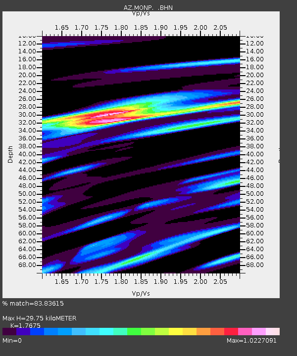
| Estimated Moho Depth: |
29.75 km |
| Estimated Crust Vp/Vs: |
1.77 |
| Assumed Crust Vp: |
6.264 km/s |
| Estimated Crust Vs: |
3.544 km/s |
| Estimated Crust Poisson's Ratio: |
0.26 |
|
| Radial Match: |
83.83615 % |
| Radial Bump: |
400 |
| Transverse Match: |
62.960438 % |
| Transverse Bump: |
400 |
| SOD ConfigId: |
32974 |
| Insert Time: |
2010-02-26 19:58:26.682 +0000 |
| GWidth: |
2.5 |
| Max Bumps: |
400 |
| Tol: |
0.001 |
|

Signal To Noise
| Channel | StoN | STA | LTA |
| AZ:MONP: :BHN:20011223T23:05:22.35002Z | 2.3457081 | 8.333136E-7 | 3.5525036E-7 |
| AZ:MONP: :BHE:20011223T23:05:22.35002Z | 2.0220835 | 5.369399E-7 | 2.6553795E-7 |
| AZ:MONP: :BHZ:20011223T23:05:22.35002Z | 1.9407794 | 5.3254115E-7 | 2.743955E-7 |
| Arrivals |
| Ps | 3.7 SECOND |
| PpPs | 13 SECOND |
| PsPs/PpSs | 17 SECOND |


