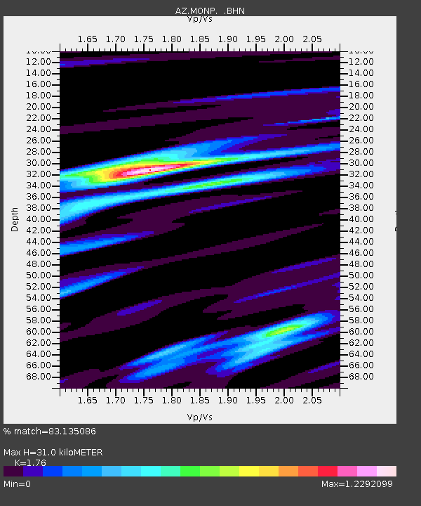
MONP AZ.MONP - Earthquake Result Viewer
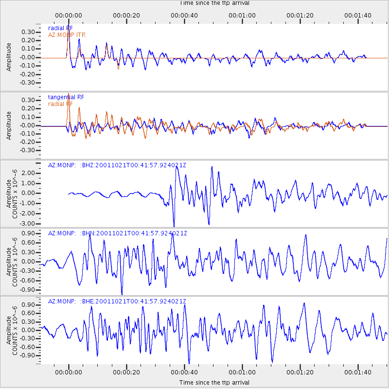
Earthquake location: Off E. Coast Of N. Island, N.Z.
Earthquake latitude/longitude: -37.1/179.0
Earthquake time(UTC): 2001/10/21 (294) 00:29:21 GMT
Earthquake Depth: 18 km
Earthquake Magnitude: 6.0 MB, 6.8 MS, 6.7 MW, 6.6 MW
Earthquake Catalog/Contributor: WHDF/NEIC
Network: AZ ANZA Regional Network
Station: MONP AZ.MONP
Lat/Lon: 32.89 N/116.42 W
Elevation: 1920 m
Distance: 92.1 deg
Az: 49.508 deg
Baz: 226.248 deg
Ray Param: 0.041508168
Estimated Moho Depth: 31.0 km
Estimated Crust Vp/Vs: 1.76
Assumed Crust Vp: 6.264 km/s
Estimated Crust Vs: 3.559 km/s
Estimated Crust Poisson's Ratio: 0.26
Radial Match: 83.135086 %
Radial Bump: 339
Transverse Match: 78.77531 %
Transverse Bump: 400
SOD ConfigId: 32974
Insert Time: 2010-02-26 19:58:28.123 +0000
GWidth: 2.5
Max Bumps: 400
Tol: 0.001

Signal To Noise

ChannelStoNSTALTA
AZ:MONP: :BHN:20011021T00:41:57.924021Z3.0757863.891711E-71.2652735E-7
AZ:MONP: :BHE:20011021T00:41:57.924021Z1.30254641.8863693E-71.4482166E-7
AZ:MONP: :BHZ:20011021T00:41:57.924021Z3.49213625.8703597E-71.6810225E-7
Arrivals
Ps3.8 SECOND
PpPs13 SECOND
PsPs/PpSs17 SECOND