You are here: Home > Network List > TA - USArray Transportable Network (new EarthScope stations) Stations List
> Station Z41A Richland Creek Farm, El Dorado, AR, USA > Earthquake Result Viewer
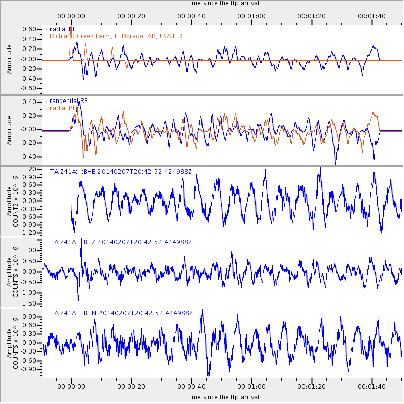
Z41A Richland Creek Farm, El Dorado, AR, USA - Earthquake Result Viewer
*The percent match for this event was below the threshold and hence no stack was calculated.
| Earthquake location: |
Northern Colombia |
| Earthquake latitude/longitude: |
6.8/-73.1 |
| Earthquake time(UTC): |
2014/02/07 (038) 20:37:10 GMT |
| Earthquake Depth: |
158 km |
| Earthquake Magnitude: |
5.3 MW |
| Earthquake Catalog/Contributor: |
ISC/ISC |
|
| Network: |
TA USArray Transportable Network (new EarthScope stations) |
| Station: |
Z41A Richland Creek Farm, El Dorado, AR, USA |
| Lat/Lon: |
33.26 N/92.80 W |
| Elevation: |
62 m |
|
| Distance: |
32.1 deg |
| Az: |
327.804 deg |
| Baz: |
140.84 deg |
| Ray Param: |
$rayparam |
*The percent match for this event was below the threshold and hence was not used in the summary stack. |
|
| Radial Match: |
51.191628 % |
| Radial Bump: |
400 |
| Transverse Match: |
43.608418 % |
| Transverse Bump: |
346 |
| SOD ConfigId: |
3390531 |
| Insert Time: |
2019-04-10 06:46:52.572 +0000 |
| GWidth: |
2.5 |
| Max Bumps: |
400 |
| Tol: |
0.001 |
|
Signal To Noise
| Channel | StoN | STA | LTA |
| TA:Z41A: :BHZ:20140207T20:42:52.424988Z | 2.6468043 | 5.333411E-7 | 2.0150378E-7 |
| TA:Z41A: :BHN:20140207T20:42:52.424988Z | 0.6696182 | 2.388004E-7 | 3.5662174E-7 |
| TA:Z41A: :BHE:20140207T20:42:52.424988Z | 0.57333106 | 2.385993E-7 | 4.1616323E-7 |
| Arrivals |
| Ps | |
| PpPs | |
| PsPs/PpSs | |


