You are here: Home > Network List > TA - USArray Transportable Network (new EarthScope stations) Stations List
> Station T31A Randall Ranch, Ashland, KS, USA > Earthquake Result Viewer
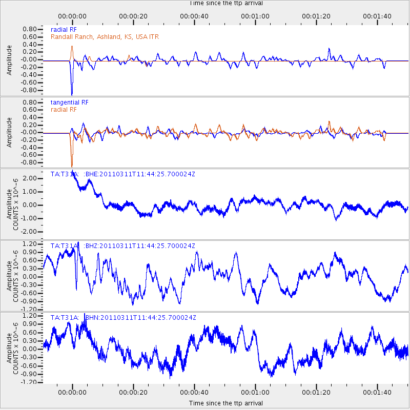
T31A Randall Ranch, Ashland, KS, USA - Earthquake Result Viewer
*The percent match for this event was below the threshold and hence no stack was calculated.
| Earthquake location: |
Off East Coast Of Honshu, Japan |
| Earthquake latitude/longitude: |
36.2/142.4 |
| Earthquake time(UTC): |
2011/03/11 (070) 11:32:14 GMT |
| Earthquake Depth: |
35 km |
| Earthquake Magnitude: |
5.7 MB |
| Earthquake Catalog/Contributor: |
WHDF/NEIC |
|
| Network: |
TA USArray Transportable Network (new EarthScope stations) |
| Station: |
T31A Randall Ranch, Ashland, KS, USA |
| Lat/Lon: |
37.10 N/99.68 W |
| Elevation: |
564 m |
|
| Distance: |
87.1 deg |
| Az: |
45.02 deg |
| Baz: |
314.338 deg |
| Ray Param: |
$rayparam |
*The percent match for this event was below the threshold and hence was not used in the summary stack. |
|
| Radial Match: |
76.043655 % |
| Radial Bump: |
400 |
| Transverse Match: |
43.116505 % |
| Transverse Bump: |
400 |
| SOD ConfigId: |
356183 |
| Insert Time: |
2011-08-15 06:50:42.423 +0000 |
| GWidth: |
2.5 |
| Max Bumps: |
400 |
| Tol: |
0.001 |
|
Signal To Noise
| Channel | StoN | STA | LTA |
| TA:T31A: :BHZ:20110311T11:44:25.700024Z | 1.4506687 | 1.2575222E-6 | 8.6685685E-7 |
| TA:T31A: :BHN:20110311T11:44:25.700024Z | 1.3808696 | 9.933699E-7 | 7.1937995E-7 |
| TA:T31A: :BHE:20110311T11:44:25.700024Z | 0.6266153 | 5.4640464E-7 | 8.719938E-7 |
| Arrivals |
| Ps | |
| PpPs | |
| PsPs/PpSs | |


