You are here: Home > Network List > TA - USArray Transportable Network (new EarthScope stations) Stations List
> Station Q31A Ellis, KS, USA > Earthquake Result Viewer
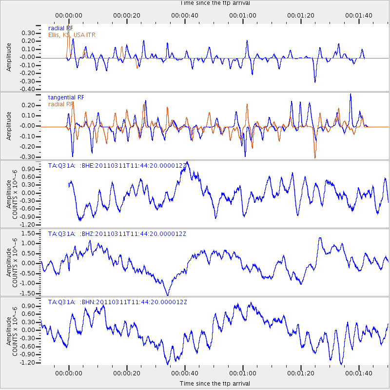
Q31A Ellis, KS, USA - Earthquake Result Viewer
*The percent match for this event was below the threshold and hence no stack was calculated.
| Earthquake location: |
Off East Coast Of Honshu, Japan |
| Earthquake latitude/longitude: |
36.2/142.4 |
| Earthquake time(UTC): |
2011/03/11 (070) 11:32:14 GMT |
| Earthquake Depth: |
35 km |
| Earthquake Magnitude: |
5.7 MB |
| Earthquake Catalog/Contributor: |
WHDF/NEIC |
|
| Network: |
TA USArray Transportable Network (new EarthScope stations) |
| Station: |
Q31A Ellis, KS, USA |
| Lat/Lon: |
39.00 N/99.39 W |
| Elevation: |
680 m |
|
| Distance: |
85.9 deg |
| Az: |
43.5 deg |
| Baz: |
314.419 deg |
| Ray Param: |
$rayparam |
*The percent match for this event was below the threshold and hence was not used in the summary stack. |
|
| Radial Match: |
45.49964 % |
| Radial Bump: |
400 |
| Transverse Match: |
60.989643 % |
| Transverse Bump: |
362 |
| SOD ConfigId: |
356183 |
| Insert Time: |
2011-08-15 06:54:06.504 +0000 |
| GWidth: |
2.5 |
| Max Bumps: |
400 |
| Tol: |
0.001 |
|
Signal To Noise
| Channel | StoN | STA | LTA |
| TA:Q31A: :BHZ:20110311T11:44:20.000012Z | 2.2733755 | 8.680218E-7 | 3.8182068E-7 |
| TA:Q31A: :BHN:20110311T11:44:20.000012Z | 1.0331142 | 3.6389926E-7 | 3.5223528E-7 |
| TA:Q31A: :BHE:20110311T11:44:20.000012Z | 0.49929157 | 2.0494927E-7 | 4.1048014E-7 |
| Arrivals |
| Ps | |
| PpPs | |
| PsPs/PpSs | |


