You are here: Home > Network List > AZ - ANZA Regional Network Stations List
> Station MONP AZ.MONP > Earthquake Result Viewer
MONP AZ.MONP - Earthquake Result Viewer

| Earthquake location: |
South Of Fiji Islands |
| Earthquake latitude/longitude: |
-23.6/178.5 |
| Earthquake time(UTC): |
2002/08/19 (231) 11:03:13 GMT |
| Earthquake Depth: |
650 km |
| Earthquake Magnitude: |
5.9 MB |
| Earthquake Catalog/Contributor: |
WHDF/NEIC |
|
| Network: |
AZ ANZA Regional Network |
| Station: |
MONP AZ.MONP |
| Lat/Lon: |
32.89 N/116.42 W |
| Elevation: |
1920 m |
|
| Distance: |
83.6 deg |
| Az: |
50.128 deg |
| Baz: |
236.826 deg |
| Ray Param: |
0.044074073 |
| Estimated Moho Depth: |
30.0 km |
| Estimated Crust Vp/Vs: |
1.80 |
| Assumed Crust Vp: |
6.264 km/s |
| Estimated Crust Vs: |
3.475 km/s |
| Estimated Crust Poisson's Ratio: |
0.28 |
|
| Radial Match: |
87.33511 % |
| Radial Bump: |
400 |
| Transverse Match: |
75.643265 % |
| Transverse Bump: |
400 |
| SOD ConfigId: |
32974 |
| Insert Time: |
2010-02-26 19:58:31.971 +0000 |
| GWidth: |
2.5 |
| Max Bumps: |
400 |
| Tol: |
0.001 |
|
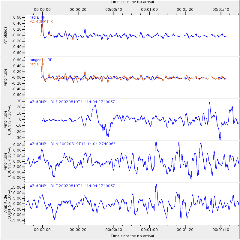
Signal To Noise
| Channel | StoN | STA | LTA |
| AZ:MONP: :BHN:20020819T11:14:04.274006Z | 2.975857 | 3.3706547E-6 | 1.1326669E-6 |
| AZ:MONP: :BHE:20020819T11:14:04.274006Z | 3.1188748 | 4.589721E-6 | 1.4715952E-6 |
| AZ:MONP: :BHZ:20020819T11:14:04.274006Z | 4.747122 | 1.3668036E-5 | 2.8792263E-6 |
| Arrivals |
| Ps | 3.9 SECOND |
| PpPs | 13 SECOND |
| PsPs/PpSs | 17 SECOND |


