You are here: Home > Network List > TA - USArray Transportable Network (new EarthScope stations) Stations List
> Station N32A Stulken Farm, Doniphan, NE, USA > Earthquake Result Viewer
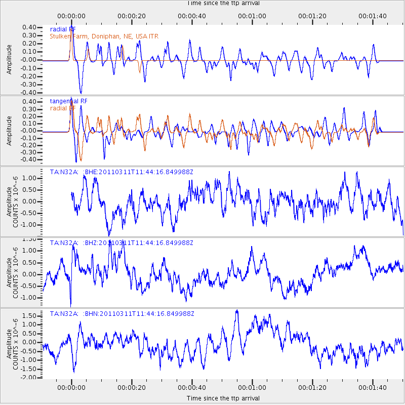
N32A Stulken Farm, Doniphan, NE, USA - Earthquake Result Viewer
*The percent match for this event was below the threshold and hence no stack was calculated.
| Earthquake location: |
Off East Coast Of Honshu, Japan |
| Earthquake latitude/longitude: |
36.2/142.4 |
| Earthquake time(UTC): |
2011/03/11 (070) 11:32:14 GMT |
| Earthquake Depth: |
35 km |
| Earthquake Magnitude: |
5.7 MB |
| Earthquake Catalog/Contributor: |
WHDF/NEIC |
|
| Network: |
TA USArray Transportable Network (new EarthScope stations) |
| Station: |
N32A Stulken Farm, Doniphan, NE, USA |
| Lat/Lon: |
40.76 N/98.30 W |
| Elevation: |
587 m |
|
| Distance: |
85.3 deg |
| Az: |
41.651 deg |
| Baz: |
314.979 deg |
| Ray Param: |
$rayparam |
*The percent match for this event was below the threshold and hence was not used in the summary stack. |
|
| Radial Match: |
51.66652 % |
| Radial Bump: |
400 |
| Transverse Match: |
42.317093 % |
| Transverse Bump: |
400 |
| SOD ConfigId: |
356183 |
| Insert Time: |
2011-08-15 07:04:23.574 +0000 |
| GWidth: |
2.5 |
| Max Bumps: |
400 |
| Tol: |
0.001 |
|
Signal To Noise
| Channel | StoN | STA | LTA |
| TA:N32A: :BHZ:20110311T11:44:16.849988Z | 2.265797 | 8.502514E-7 | 3.7525493E-7 |
| TA:N32A: :BHN:20110311T11:44:16.849988Z | 1.3042632 | 8.182723E-7 | 6.273828E-7 |
| TA:N32A: :BHE:20110311T11:44:16.849988Z | 0.9769319 | 5.7362746E-7 | 5.871724E-7 |
| Arrivals |
| Ps | |
| PpPs | |
| PsPs/PpSs | |


