You are here: Home > Network List > TA - USArray Transportable Network (new EarthScope stations) Stations List
> Station 633A Saathoff Ranch, Hondo, TX, USA > Earthquake Result Viewer
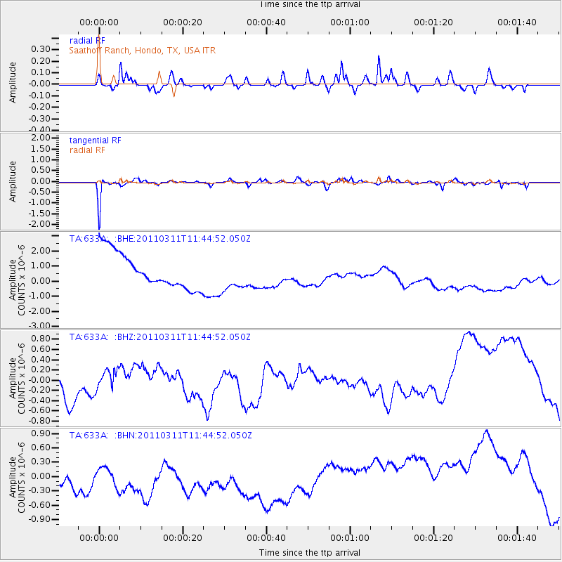
633A Saathoff Ranch, Hondo, TX, USA - Earthquake Result Viewer
*The percent match for this event was below the threshold and hence no stack was calculated.
| Earthquake location: |
Off East Coast Of Honshu, Japan |
| Earthquake latitude/longitude: |
36.2/142.4 |
| Earthquake time(UTC): |
2011/03/11 (070) 11:32:14 GMT |
| Earthquake Depth: |
35 km |
| Earthquake Magnitude: |
5.7 MB |
| Earthquake Catalog/Contributor: |
WHDF/NEIC |
|
| Network: |
TA USArray Transportable Network (new EarthScope stations) |
| Station: |
633A Saathoff Ranch, Hondo, TX, USA |
| Lat/Lon: |
29.46 N/99.18 W |
| Elevation: |
320 m |
|
| Distance: |
92.7 deg |
| Az: |
50.159 deg |
| Baz: |
314.62 deg |
| Ray Param: |
$rayparam |
*The percent match for this event was below the threshold and hence was not used in the summary stack. |
|
| Radial Match: |
42.196827 % |
| Radial Bump: |
284 |
| Transverse Match: |
80.90347 % |
| Transverse Bump: |
230 |
| SOD ConfigId: |
356183 |
| Insert Time: |
2011-08-15 07:09:36.277 +0000 |
| GWidth: |
2.5 |
| Max Bumps: |
400 |
| Tol: |
0.001 |
|
Signal To Noise
| Channel | StoN | STA | LTA |
| TA:633A: :BHZ:20110311T11:44:52.050Z | 0.49672702 | 3.1135843E-7 | 6.2682E-7 |
| TA:633A: :BHN:20110311T11:44:52.050Z | 0.8764948 | 1.0899151E-6 | 1.243493E-6 |
| TA:633A: :BHE:20110311T11:44:52.050Z | 0.9146278 | 1.0595994E-6 | 1.1585034E-6 |
| Arrivals |
| Ps | |
| PpPs | |
| PsPs/PpSs | |


