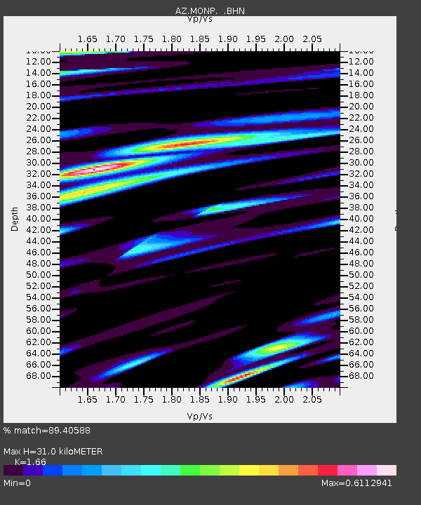
MONP AZ.MONP - Earthquake Result Viewer
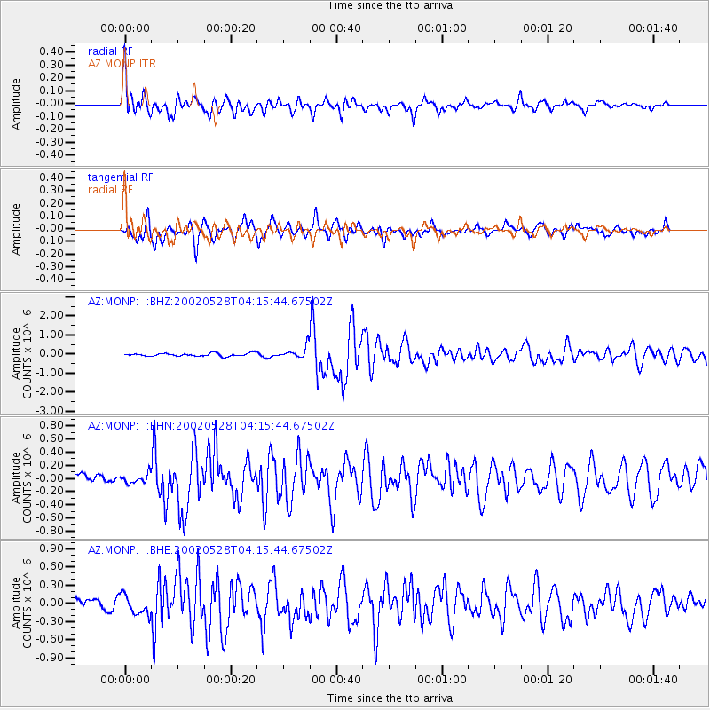
Earthquake location: Catamarca Province, Argentina
Earthquake latitude/longitude: -28.9/-66.8
Earthquake time(UTC): 2002/05/28 (148) 04:04:22 GMT
Earthquake Depth: 22 km
Earthquake Magnitude: 6.0 MB, 5.7 MS, 6.0 MW, 5.9 MW
Earthquake Catalog/Contributor: WHDF/NEIC
Network: AZ ANZA Regional Network
Station: MONP AZ.MONP
Lat/Lon: 32.89 N/116.42 W
Elevation: 1920 m
Distance: 77.4 deg
Az: 318.952 deg
Baz: 136.832 deg
Ray Param: 0.05030087
Estimated Moho Depth: 31.0 km
Estimated Crust Vp/Vs: 1.66
Assumed Crust Vp: 6.264 km/s
Estimated Crust Vs: 3.773 km/s
Estimated Crust Poisson's Ratio: 0.22
Radial Match: 89.40588 %
Radial Bump: 400
Transverse Match: 86.03873 %
Transverse Bump: 400
SOD ConfigId: 32974
Insert Time: 2010-02-26 19:58:40.801 +0000
GWidth: 2.5
Max Bumps: 400
Tol: 0.001

Signal To Noise

ChannelStoNSTALTA
AZ:MONP: :BHN:20020528T04:15:44.67502Z0.93698046.8821265E-87.345006E-8
AZ:MONP: :BHE:20020528T04:15:44.67502Z2.03698681.6133136E-77.920098E-8
AZ:MONP: :BHZ:20020528T04:15:44.67502Z3.92114192.9888446E-77.6223834E-8
Arrivals
Ps3.4 SECOND
PpPs13 SECOND
PsPs/PpSs16 SECOND