You are here: Home > Network List > TA - USArray Transportable Network (new EarthScope stations) Stations List
> Station N34A Lincoln, NE, USA > Earthquake Result Viewer
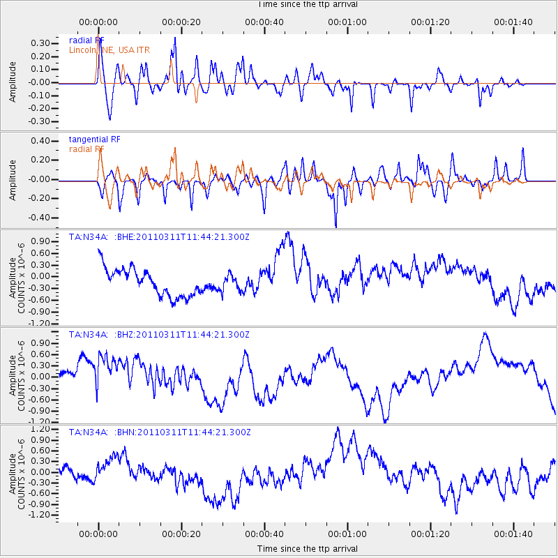
N34A Lincoln, NE, USA - Earthquake Result Viewer
*The percent match for this event was below the threshold and hence no stack was calculated.
| Earthquake location: |
Off East Coast Of Honshu, Japan |
| Earthquake latitude/longitude: |
36.2/142.4 |
| Earthquake time(UTC): |
2011/03/11 (070) 11:32:14 GMT |
| Earthquake Depth: |
35 km |
| Earthquake Magnitude: |
5.7 MB |
| Earthquake Catalog/Contributor: |
WHDF/NEIC |
|
| Network: |
TA USArray Transportable Network (new EarthScope stations) |
| Station: |
N34A Lincoln, NE, USA |
| Lat/Lon: |
40.84 N/96.50 W |
| Elevation: |
401 m |
|
| Distance: |
86.2 deg |
| Az: |
40.624 deg |
| Baz: |
316.071 deg |
| Ray Param: |
$rayparam |
*The percent match for this event was below the threshold and hence was not used in the summary stack. |
|
| Radial Match: |
48.79421 % |
| Radial Bump: |
370 |
| Transverse Match: |
51.80347 % |
| Transverse Bump: |
379 |
| SOD ConfigId: |
356183 |
| Insert Time: |
2011-08-15 07:21:03.805 +0000 |
| GWidth: |
2.5 |
| Max Bumps: |
400 |
| Tol: |
0.001 |
|
Signal To Noise
| Channel | StoN | STA | LTA |
| TA:N34A: :BHZ:20110311T11:44:21.300Z | 1.8831009 | 4.981447E-7 | 2.6453424E-7 |
| TA:N34A: :BHN:20110311T11:44:21.300Z | 0.97475713 | 2.248799E-7 | 2.3070352E-7 |
| TA:N34A: :BHE:20110311T11:44:21.300Z | 0.5866552 | 2.049997E-7 | 3.4943812E-7 |
| Arrivals |
| Ps | |
| PpPs | |
| PsPs/PpSs | |


