You are here: Home > Network List > TA - USArray Transportable Network (new EarthScope stations) Stations List
> Station N35A Tabor, IA, USA > Earthquake Result Viewer
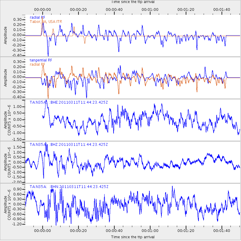
N35A Tabor, IA, USA - Earthquake Result Viewer
*The percent match for this event was below the threshold and hence no stack was calculated.
| Earthquake location: |
Off East Coast Of Honshu, Japan |
| Earthquake latitude/longitude: |
36.2/142.4 |
| Earthquake time(UTC): |
2011/03/11 (070) 11:32:14 GMT |
| Earthquake Depth: |
35 km |
| Earthquake Magnitude: |
5.7 MB |
| Earthquake Catalog/Contributor: |
WHDF/NEIC |
|
| Network: |
TA USArray Transportable Network (new EarthScope stations) |
| Station: |
N35A Tabor, IA, USA |
| Lat/Lon: |
40.86 N/95.64 W |
| Elevation: |
353 m |
|
| Distance: |
86.6 deg |
| Az: |
40.136 deg |
| Baz: |
316.6 deg |
| Ray Param: |
$rayparam |
*The percent match for this event was below the threshold and hence was not used in the summary stack. |
|
| Radial Match: |
50.597984 % |
| Radial Bump: |
400 |
| Transverse Match: |
45.983757 % |
| Transverse Bump: |
368 |
| SOD ConfigId: |
356183 |
| Insert Time: |
2011-08-15 07:21:08.951 +0000 |
| GWidth: |
2.5 |
| Max Bumps: |
400 |
| Tol: |
0.001 |
|
Signal To Noise
| Channel | StoN | STA | LTA |
| TA:N35A: :BHZ:20110311T11:44:23.425Z | 3.3532252 | 9.631525E-7 | 2.8723167E-7 |
| TA:N35A: :BHN:20110311T11:44:23.425Z | 2.242223 | 7.7270727E-7 | 3.4461658E-7 |
| TA:N35A: :BHE:20110311T11:44:23.425Z | 0.82939905 | 4.511253E-7 | 5.439183E-7 |
| Arrivals |
| Ps | |
| PpPs | |
| PsPs/PpSs | |


