You are here: Home > Network List > AZ - ANZA Regional Network Stations List
> Station MONP AZ.MONP > Earthquake Result Viewer
MONP AZ.MONP - Earthquake Result Viewer
| Earthquake location: |
Chile-Bolivia Border Region |
| Earthquake latitude/longitude: |
-21.7/-68.3 |
| Earthquake time(UTC): |
2002/03/28 (087) 04:56:22 GMT |
| Earthquake Depth: |
125 km |
| Earthquake Magnitude: |
6.1 MB, 6.5 MW, 6.5 MW |
| Earthquake Catalog/Contributor: |
WHDF/NEIC |
|
| Network: |
AZ ANZA Regional Network |
| Station: |
MONP AZ.MONP |
| Lat/Lon: |
32.89 N/116.42 W |
| Elevation: |
1920 m |
|
| Distance: |
71.1 deg |
| Az: |
318.551 deg |
| Baz: |
132.956 deg |
| Ray Param: |
0.054247834 |
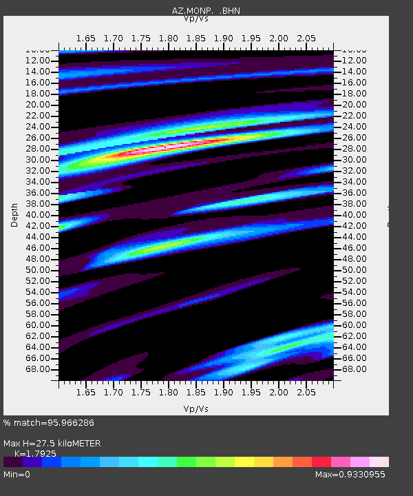
| Estimated Moho Depth: |
27.5 km |
| Estimated Crust Vp/Vs: |
1.79 |
| Assumed Crust Vp: |
6.264 km/s |
| Estimated Crust Vs: |
3.494 km/s |
| Estimated Crust Poisson's Ratio: |
0.27 |
|
| Radial Match: |
95.966286 % |
| Radial Bump: |
400 |
| Transverse Match: |
91.973816 % |
| Transverse Bump: |
400 |
| SOD ConfigId: |
32974 |
| Insert Time: |
2010-02-26 19:58:45.768 +0000 |
| GWidth: |
2.5 |
| Max Bumps: |
400 |
| Tol: |
0.001 |
|

Signal To Noise
| Channel | StoN | STA | LTA |
| AZ:MONP: :BHN:20020328T05:06:56.100012Z | 3.9267197 | 4.8903524E-7 | 1.245404E-7 |
| AZ:MONP: :BHE:20020328T05:06:56.100012Z | 7.5239153 | 6.7914124E-7 | 9.026434E-8 |
| AZ:MONP: :BHZ:20020328T05:06:56.100012Z | 16.161919 | 1.9594581E-6 | 1.212392E-7 |
| Arrivals |
| Ps | 3.6 SECOND |
| PpPs | 12 SECOND |
| PsPs/PpSs | 15 SECOND |


